You are here: Home > Network List > CN - Canadian National Seismograph Network Stations List
> Station INK INUVIK, NT > Earthquake Result Viewer
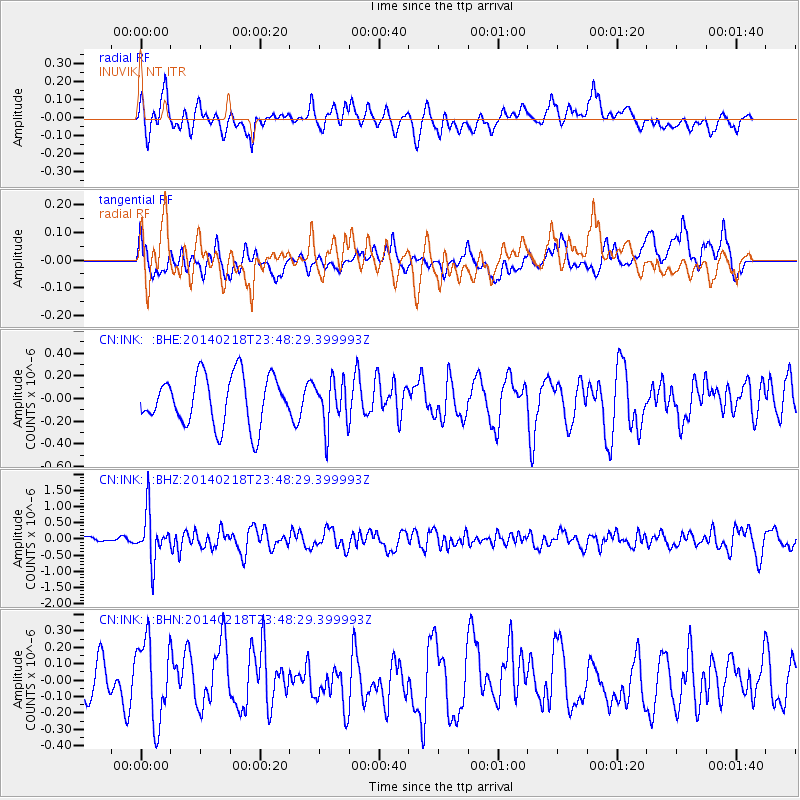
INK INUVIK, NT - Earthquake Result Viewer
*The percent match for this event was below the threshold and hence no stack was calculated.
| Earthquake location: |
Near Coast Of Peru |
| Earthquake latitude/longitude: |
-14.2/-75.6 |
| Earthquake time(UTC): |
2014/02/18 (049) 23:35:58 GMT |
| Earthquake Depth: |
57 km |
| Earthquake Magnitude: |
6.0 MWB, 5.9 MWW, 5.9 MWC, 6.0 MWC |
| Earthquake Catalog/Contributor: |
NEIC PDE/NEIC COMCAT |
|
| Network: |
CN Canadian National Seismograph Network |
| Station: |
INK INUVIK, NT |
| Lat/Lon: |
68.31 N/133.53 W |
| Elevation: |
44 m |
|
| Distance: |
92.0 deg |
| Az: |
341.626 deg |
| Baz: |
124.674 deg |
| Ray Param: |
$rayparam |
*The percent match for this event was below the threshold and hence was not used in the summary stack. |
|
| Radial Match: |
63.772236 % |
| Radial Bump: |
400 |
| Transverse Match: |
57.299107 % |
| Transverse Bump: |
400 |
| SOD ConfigId: |
626651 |
| Insert Time: |
2014-04-20 19:52:07.905 +0000 |
| GWidth: |
2.5 |
| Max Bumps: |
400 |
| Tol: |
0.001 |
|
Signal To Noise
| Channel | StoN | STA | LTA |
| CN:INK: :BHZ:20140218T23:48:29.399993Z | 3.372839 | 7.358495E-7 | 2.1816919E-7 |
| CN:INK: :BHN:20140218T23:48:29.399993Z | 2.5447373 | 2.512759E-7 | 9.874336E-8 |
| CN:INK: :BHE:20140218T23:48:29.399993Z | 0.93328 | 2.028837E-7 | 2.1738782E-7 |
| Arrivals |
| Ps | |
| PpPs | |
| PsPs/PpSs | |


