You are here: Home > Network List > TA - USArray Transportable Network (new EarthScope stations) Stations List
> Station G59A Clarenceville, QC, USA > Earthquake Result Viewer
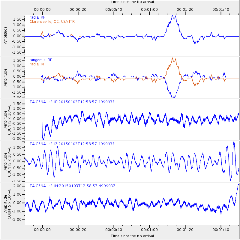
G59A Clarenceville, QC, USA - Earthquake Result Viewer
*The percent match for this event was below the threshold and hence no stack was calculated.
| Earthquake location: |
Afghanistan-Tajikistan Bord Reg. |
| Earthquake latitude/longitude: |
37.3/71.9 |
| Earthquake time(UTC): |
2015/01/03 (003) 12:46:34 GMT |
| Earthquake Depth: |
130 km |
| Earthquake Magnitude: |
4.8 MW, 4.8 mb |
| Earthquake Catalog/Contributor: |
ISC/ISC |
|
| Network: |
TA USArray Transportable Network (new EarthScope stations) |
| Station: |
G59A Clarenceville, QC, USA |
| Lat/Lon: |
45.08 N/73.18 W |
| Elevation: |
36 m |
|
| Distance: |
92.1 deg |
| Az: |
336.029 deg |
| Baz: |
27.219 deg |
| Ray Param: |
$rayparam |
*The percent match for this event was below the threshold and hence was not used in the summary stack. |
|
| Radial Match: |
13.72985 % |
| Radial Bump: |
400 |
| Transverse Match: |
17.550611 % |
| Transverse Bump: |
400 |
| SOD ConfigId: |
3390531 |
| Insert Time: |
2019-04-15 22:10:07.341 +0000 |
| GWidth: |
2.5 |
| Max Bumps: |
400 |
| Tol: |
0.001 |
|
Signal To Noise
| Channel | StoN | STA | LTA |
| TA:G59A: :BHZ:20150103T12:58:57.499993Z | 1.8129579 | 5.772782E-7 | 3.1841785E-7 |
| TA:G59A: :BHN:20150103T12:58:57.499993Z | 0.8448535 | 1.4967028E-6 | 1.771553E-6 |
| TA:G59A: :BHE:20150103T12:58:57.499993Z | 0.819805 | 5.276402E-7 | 6.436168E-7 |
| Arrivals |
| Ps | |
| PpPs | |
| PsPs/PpSs | |


