You are here: Home > Network List > LD - Lamont-Doherty Cooperative Seismographic Network Stations List
> Station MVL Millersville University, PA > Earthquake Result Viewer
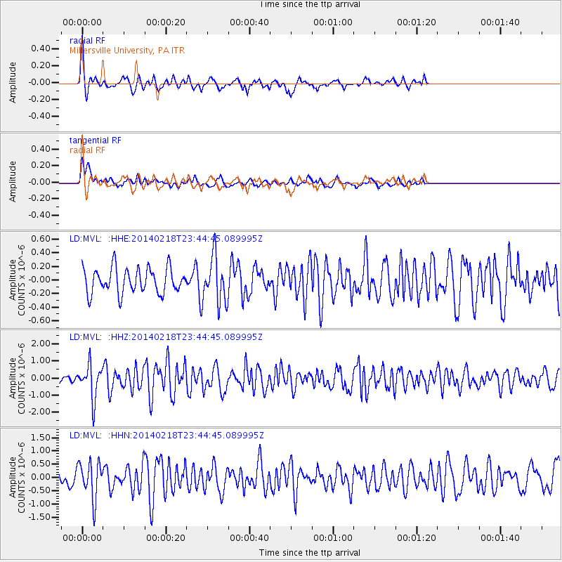
MVL Millersville University, PA - Earthquake Result Viewer
*The percent match for this event was below the threshold and hence no stack was calculated.
| Earthquake location: |
Near Coast Of Peru |
| Earthquake latitude/longitude: |
-14.2/-75.6 |
| Earthquake time(UTC): |
2014/02/18 (049) 23:35:58 GMT |
| Earthquake Depth: |
57 km |
| Earthquake Magnitude: |
6.0 MWB, 5.9 MWW, 5.9 MWC, 6.0 MWC |
| Earthquake Catalog/Contributor: |
NEIC PDE/NEIC COMCAT |
|
| Network: |
LD Lamont-Doherty Cooperative Seismographic Network |
| Station: |
MVL Millersville University, PA |
| Lat/Lon: |
40.00 N/76.35 W |
| Elevation: |
91 m |
|
| Distance: |
53.9 deg |
| Az: |
359.288 deg |
| Baz: |
179.101 deg |
| Ray Param: |
$rayparam |
*The percent match for this event was below the threshold and hence was not used in the summary stack. |
|
| Radial Match: |
63.601242 % |
| Radial Bump: |
267 |
| Transverse Match: |
56.450996 % |
| Transverse Bump: |
354 |
| SOD ConfigId: |
626651 |
| Insert Time: |
2014-04-20 19:58:51.898 +0000 |
| GWidth: |
2.5 |
| Max Bumps: |
400 |
| Tol: |
0.001 |
|
Signal To Noise
| Channel | StoN | STA | LTA |
| LD:MVL: :HHZ:20140218T23:44:45.089995Z | 3.3731477 | 1.0172838E-6 | 3.0158293E-7 |
| LD:MVL: :HHN:20140218T23:44:45.089995Z | 3.904652 | 7.13019E-7 | 1.8260756E-7 |
| LD:MVL: :HHE:20140218T23:44:45.089995Z | 1.8202909 | 3.3342542E-7 | 1.831715E-7 |
| Arrivals |
| Ps | |
| PpPs | |
| PsPs/PpSs | |


