You are here: Home > Network List > TA - USArray Transportable Network (new EarthScope stations) Stations List
> Station D58A Chemin du LacGrosbois, Trois-Rives, QC, CAN > Earthquake Result Viewer
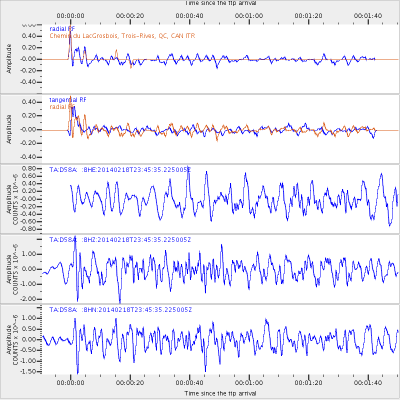
D58A Chemin du LacGrosbois, Trois-Rives, QC, CAN - Earthquake Result Viewer
*The percent match for this event was below the threshold and hence no stack was calculated.
| Earthquake location: |
Near Coast Of Peru |
| Earthquake latitude/longitude: |
-14.2/-75.6 |
| Earthquake time(UTC): |
2014/02/18 (049) 23:35:58 GMT |
| Earthquake Depth: |
57 km |
| Earthquake Magnitude: |
6.0 MWB, 5.9 MWW, 5.9 MWC, 6.0 MWC |
| Earthquake Catalog/Contributor: |
NEIC PDE/NEIC COMCAT |
|
| Network: |
TA USArray Transportable Network (new EarthScope stations) |
| Station: |
D58A Chemin du LacGrosbois, Trois-Rives, QC, CAN |
| Lat/Lon: |
47.10 N/72.88 W |
| Elevation: |
398 m |
|
| Distance: |
61.0 deg |
| Az: |
2.124 deg |
| Baz: |
183.016 deg |
| Ray Param: |
$rayparam |
*The percent match for this event was below the threshold and hence was not used in the summary stack. |
|
| Radial Match: |
62.12216 % |
| Radial Bump: |
390 |
| Transverse Match: |
60.538017 % |
| Transverse Bump: |
400 |
| SOD ConfigId: |
626651 |
| Insert Time: |
2014-04-20 20:08:38.193 +0000 |
| GWidth: |
2.5 |
| Max Bumps: |
400 |
| Tol: |
0.001 |
|
Signal To Noise
| Channel | StoN | STA | LTA |
| TA:D58A: :BHZ:20140218T23:45:35.225005Z | 4.2871933 | 1.0070239E-6 | 2.348912E-7 |
| TA:D58A: :BHN:20140218T23:45:35.225005Z | 3.168598 | 6.060701E-7 | 1.9127393E-7 |
| TA:D58A: :BHE:20140218T23:45:35.225005Z | 1.4802694 | 3.1739685E-7 | 2.1441831E-7 |
| Arrivals |
| Ps | |
| PpPs | |
| PsPs/PpSs | |


