You are here: Home > Network List > CI - Caltech Regional Seismic Network Stations List
> Station CIA Catalina Island Airport, California, USA > Earthquake Result Viewer
CIA Catalina Island Airport, California, USA - Earthquake Result Viewer
| Earthquake location: |
Off Coast Of Costa Rica |
| Earthquake latitude/longitude: |
10.7/-87.0 |
| Earthquake time(UTC): |
2004/06/29 (181) 07:01:30 GMT |
| Earthquake Depth: |
9.0 km |
| Earthquake Magnitude: |
5.8 MB, 5.8 MS, 6.3 MW, 6.1 MW |
| Earthquake Catalog/Contributor: |
WHDF/NEIC |
|
| Network: |
CI Caltech Regional Seismic Network |
| Station: |
CIA Catalina Island Airport, California, USA |
| Lat/Lon: |
33.40 N/118.42 W |
| Elevation: |
428 m |
|
| Distance: |
36.6 deg |
| Az: |
313.011 deg |
| Baz: |
120.793 deg |
| Ray Param: |
0.0766207 |
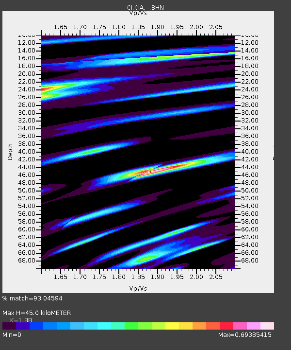
| Estimated Moho Depth: |
45.0 km |
| Estimated Crust Vp/Vs: |
1.88 |
| Assumed Crust Vp: |
6.048 km/s |
| Estimated Crust Vs: |
3.217 km/s |
| Estimated Crust Poisson's Ratio: |
0.30 |
|
| Radial Match: |
93.04594 % |
| Radial Bump: |
313 |
| Transverse Match: |
82.19016 % |
| Transverse Bump: |
400 |
| SOD ConfigId: |
2459 |
| Insert Time: |
2010-02-25 20:56:35.495 +0000 |
| GWidth: |
2.5 |
| Max Bumps: |
400 |
| Tol: |
0.001 |
|
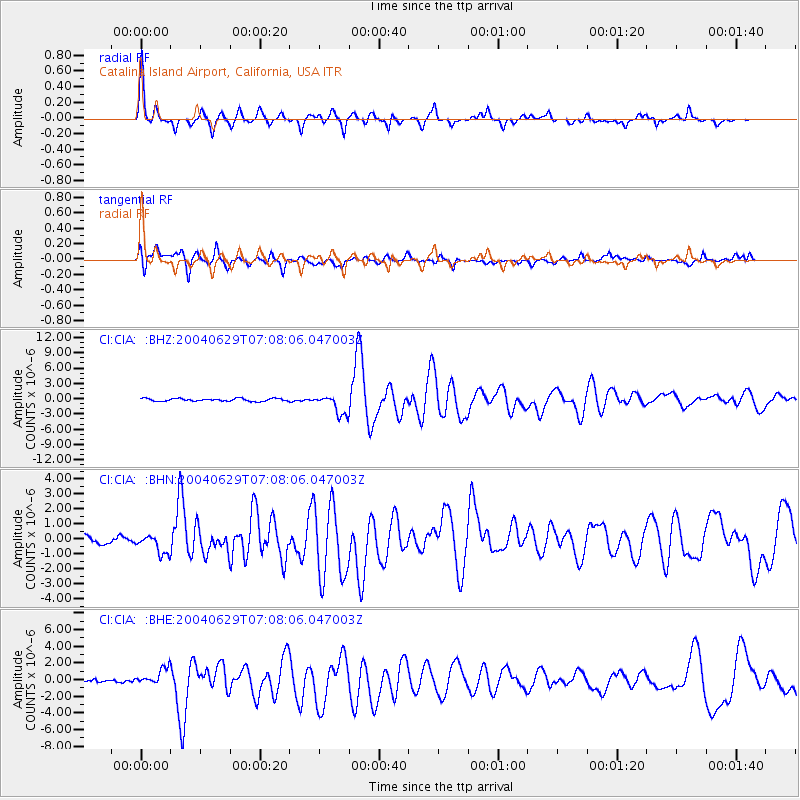
Signal To Noise
| Channel | StoN | STA | LTA |
| CI:CIA: :BHN:20040629T07:08:06.047003Z | 2.6375782 | 6.4368527E-7 | 2.4404403E-7 |
| CI:CIA: :BHE:20040629T07:08:06.047003Z | 5.048415 | 9.844757E-7 | 1.9500688E-7 |
| CI:CIA: :BHZ:20040629T07:08:06.047003Z | 7.1534333 | 1.969079E-6 | 2.752635E-7 |
| Arrivals |
| Ps | 7.0 SECOND |
| PpPs | 20 SECOND |
| PsPs/PpSs | 27 SECOND |


