You are here: Home > Network List > TA - USArray Transportable Network (new EarthScope stations) Stations List
> Station G53A Haliburton, ON, CAN > Earthquake Result Viewer
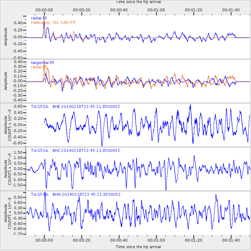
G53A Haliburton, ON, CAN - Earthquake Result Viewer
*The percent match for this event was below the threshold and hence no stack was calculated.
| Earthquake location: |
Near Coast Of Peru |
| Earthquake latitude/longitude: |
-14.2/-75.6 |
| Earthquake time(UTC): |
2014/02/18 (049) 23:35:58 GMT |
| Earthquake Depth: |
57 km |
| Earthquake Magnitude: |
6.0 MWB, 5.9 MWW, 5.9 MWC, 6.0 MWC |
| Earthquake Catalog/Contributor: |
NEIC PDE/NEIC COMCAT |
|
| Network: |
TA USArray Transportable Network (new EarthScope stations) |
| Station: |
G53A Haliburton, ON, CAN |
| Lat/Lon: |
45.12 N/78.62 W |
| Elevation: |
333 m |
|
| Distance: |
59.1 deg |
| Az: |
357.506 deg |
| Baz: |
176.582 deg |
| Ray Param: |
$rayparam |
*The percent match for this event was below the threshold and hence was not used in the summary stack. |
|
| Radial Match: |
65.41258 % |
| Radial Bump: |
400 |
| Transverse Match: |
69.74239 % |
| Transverse Bump: |
400 |
| SOD ConfigId: |
626651 |
| Insert Time: |
2014-04-20 20:10:09.242 +0000 |
| GWidth: |
2.5 |
| Max Bumps: |
400 |
| Tol: |
0.001 |
|
Signal To Noise
| Channel | StoN | STA | LTA |
| TA:G53A: :BHZ:20140218T23:45:21.850005Z | 2.5660086 | 7.090891E-7 | 2.7633934E-7 |
| TA:G53A: :BHN:20140218T23:45:21.850005Z | 2.7235951 | 5.608178E-7 | 2.0591087E-7 |
| TA:G53A: :BHE:20140218T23:45:21.850005Z | 1.7795199 | 3.4970097E-7 | 1.9651422E-7 |
| Arrivals |
| Ps | |
| PpPs | |
| PsPs/PpSs | |


