You are here: Home > Network List > TA - USArray Transportable Network (new EarthScope stations) Stations List
> Station R11A Troy Canyon, Currant, NV, USA > Earthquake Result Viewer
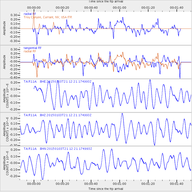
R11A Troy Canyon, Currant, NV, USA - Earthquake Result Viewer
*The percent match for this event was below the threshold and hence no stack was calculated.
| Earthquake location: |
Vanuatu Islands |
| Earthquake latitude/longitude: |
-17.3/168.8 |
| Earthquake time(UTC): |
2015/01/03 (003) 20:59:57 GMT |
| Earthquake Depth: |
35 km |
| Earthquake Magnitude: |
5.3 MW, 5.1 mb, 4.8 MS |
| Earthquake Catalog/Contributor: |
ISC/ISC |
|
| Network: |
TA USArray Transportable Network (new EarthScope stations) |
| Station: |
R11A Troy Canyon, Currant, NV, USA |
| Lat/Lon: |
38.35 N/115.59 W |
| Elevation: |
1756 m |
|
| Distance: |
89.7 deg |
| Az: |
49.594 deg |
| Baz: |
247.725 deg |
| Ray Param: |
$rayparam |
*The percent match for this event was below the threshold and hence was not used in the summary stack. |
|
| Radial Match: |
33.47149 % |
| Radial Bump: |
400 |
| Transverse Match: |
45.23573 % |
| Transverse Bump: |
400 |
| SOD ConfigId: |
3390531 |
| Insert Time: |
2019-04-15 22:20:33.727 +0000 |
| GWidth: |
2.5 |
| Max Bumps: |
400 |
| Tol: |
0.001 |
|
Signal To Noise
| Channel | StoN | STA | LTA |
| TA:R11A: :BHZ:20150103T21:12:21.174993Z | 0.3814288 | 3.711895E-8 | 9.731554E-8 |
| TA:R11A: :BHN:20150103T21:12:21.174993Z | 1.3031996 | 1.4437244E-7 | 1.1078305E-7 |
| TA:R11A: :BHE:20150103T21:12:21.174993Z | 0.82582283 | 9.740129E-8 | 1.1794454E-7 |
| Arrivals |
| Ps | |
| PpPs | |
| PsPs/PpSs | |


