You are here: Home > Network List > TA - USArray Transportable Network (new EarthScope stations) Stations List
> Station M49A Liberty Center, OH, USA > Earthquake Result Viewer
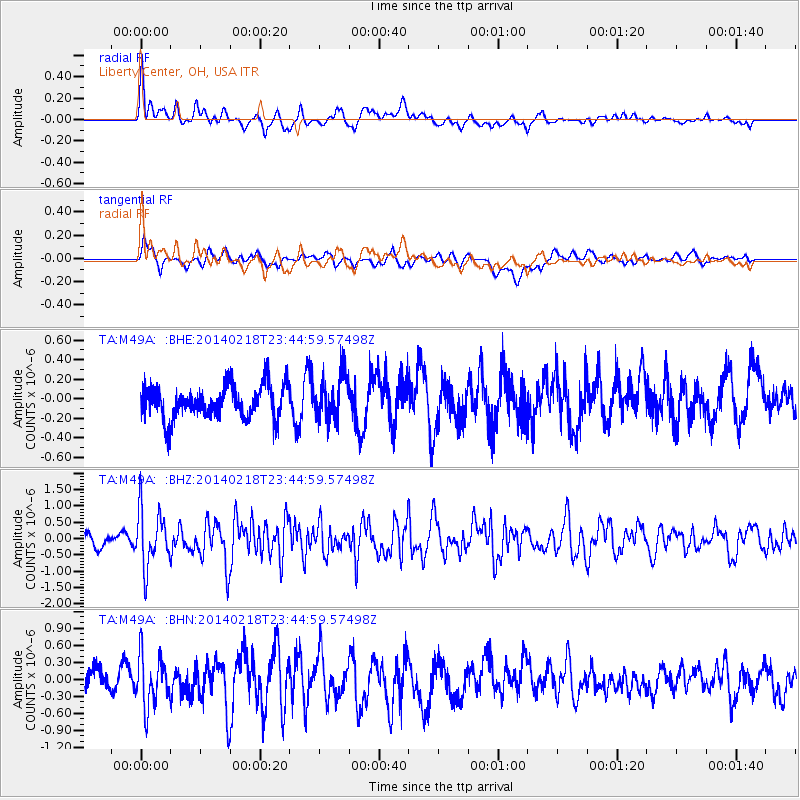
M49A Liberty Center, OH, USA - Earthquake Result Viewer
*The percent match for this event was below the threshold and hence no stack was calculated.
| Earthquake location: |
Near Coast Of Peru |
| Earthquake latitude/longitude: |
-14.2/-75.6 |
| Earthquake time(UTC): |
2014/02/18 (049) 23:35:58 GMT |
| Earthquake Depth: |
57 km |
| Earthquake Magnitude: |
6.0 MWB, 5.9 MWW, 5.9 MWC, 6.0 MWC |
| Earthquake Catalog/Contributor: |
NEIC PDE/NEIC COMCAT |
|
| Network: |
TA USArray Transportable Network (new EarthScope stations) |
| Station: |
M49A Liberty Center, OH, USA |
| Lat/Lon: |
41.47 N/83.98 W |
| Elevation: |
203 m |
|
| Distance: |
55.9 deg |
| Az: |
352.406 deg |
| Baz: |
170.177 deg |
| Ray Param: |
$rayparam |
*The percent match for this event was below the threshold and hence was not used in the summary stack. |
|
| Radial Match: |
63.83621 % |
| Radial Bump: |
400 |
| Transverse Match: |
48.73702 % |
| Transverse Bump: |
400 |
| SOD ConfigId: |
626651 |
| Insert Time: |
2014-04-20 20:14:41.624 +0000 |
| GWidth: |
2.5 |
| Max Bumps: |
400 |
| Tol: |
0.001 |
|
Signal To Noise
| Channel | StoN | STA | LTA |
| TA:M49A: :BHZ:20140218T23:44:59.57498Z | 5.3419003 | 8.7648596E-7 | 1.6407756E-7 |
| TA:M49A: :BHN:20140218T23:44:59.57498Z | 2.3931813 | 4.4225368E-7 | 1.8479739E-7 |
| TA:M49A: :BHE:20140218T23:44:59.57498Z | 1.3586934 | 2.3126974E-7 | 1.7021482E-7 |
| Arrivals |
| Ps | |
| PpPs | |
| PsPs/PpSs | |


