You are here: Home > Network List > TA - USArray Transportable Network (new EarthScope stations) Stations List
> Station T53A Wise, VA, USA > Earthquake Result Viewer
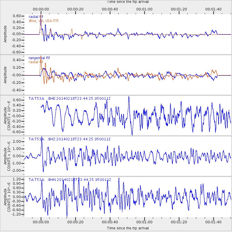
T53A Wise, VA, USA - Earthquake Result Viewer
*The percent match for this event was below the threshold and hence no stack was calculated.
| Earthquake location: |
Near Coast Of Peru |
| Earthquake latitude/longitude: |
-14.2/-75.6 |
| Earthquake time(UTC): |
2014/02/18 (049) 23:35:58 GMT |
| Earthquake Depth: |
57 km |
| Earthquake Magnitude: |
6.0 MWB, 5.9 MWW, 5.9 MWC, 6.0 MWC |
| Earthquake Catalog/Contributor: |
NEIC PDE/NEIC COMCAT |
|
| Network: |
TA USArray Transportable Network (new EarthScope stations) |
| Station: |
T53A Wise, VA, USA |
| Lat/Lon: |
36.98 N/82.54 W |
| Elevation: |
818 m |
|
| Distance: |
51.3 deg |
| Az: |
352.884 deg |
| Baz: |
171.37 deg |
| Ray Param: |
$rayparam |
*The percent match for this event was below the threshold and hence was not used in the summary stack. |
|
| Radial Match: |
70.21581 % |
| Radial Bump: |
400 |
| Transverse Match: |
63.021374 % |
| Transverse Bump: |
400 |
| SOD ConfigId: |
626651 |
| Insert Time: |
2014-04-20 20:20:12.104 +0000 |
| GWidth: |
2.5 |
| Max Bumps: |
400 |
| Tol: |
0.001 |
|
Signal To Noise
| Channel | StoN | STA | LTA |
| TA:T53A: :BHZ:20140218T23:44:25.950011Z | 5.3108883 | 1.1708829E-6 | 2.2046837E-7 |
| TA:T53A: :BHN:20140218T23:44:25.950011Z | 2.6588383 | 5.649608E-7 | 2.1248408E-7 |
| TA:T53A: :BHE:20140218T23:44:25.950011Z | 0.90386254 | 2.563485E-7 | 2.8361447E-7 |
| Arrivals |
| Ps | |
| PpPs | |
| PsPs/PpSs | |


