You are here: Home > Network List > TA - USArray Transportable Network (new EarthScope stations) Stations List
> Station V61A Roper, NC, USA > Earthquake Result Viewer
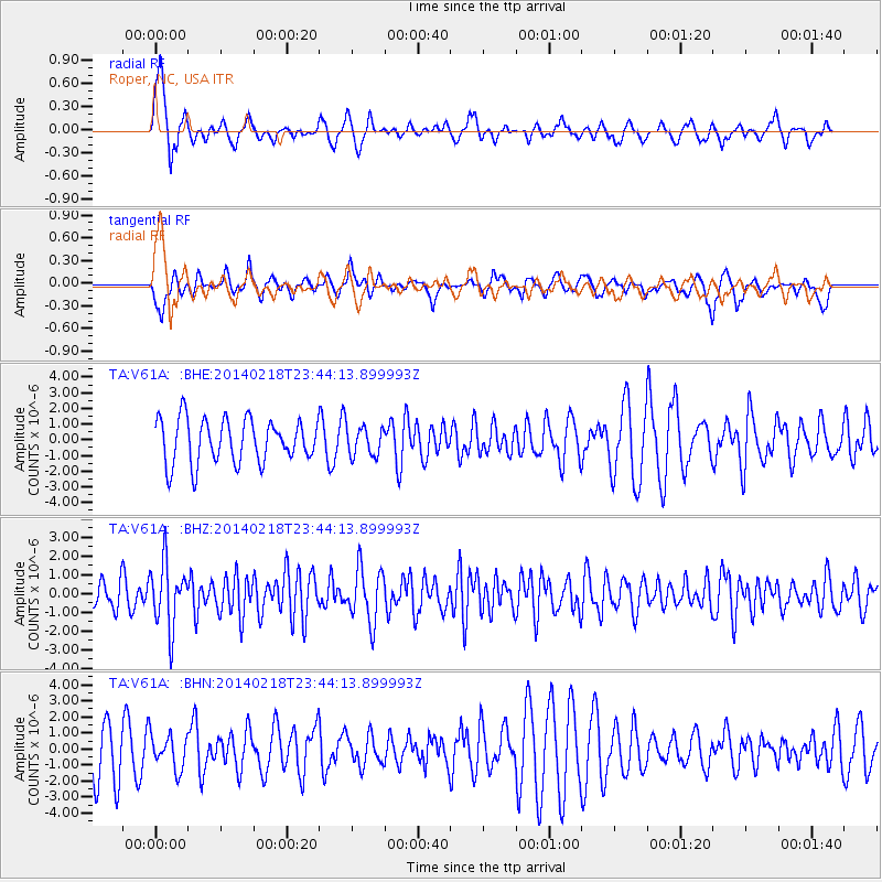
V61A Roper, NC, USA - Earthquake Result Viewer
*The percent match for this event was below the threshold and hence no stack was calculated.
| Earthquake location: |
Near Coast Of Peru |
| Earthquake latitude/longitude: |
-14.2/-75.6 |
| Earthquake time(UTC): |
2014/02/18 (049) 23:35:58 GMT |
| Earthquake Depth: |
57 km |
| Earthquake Magnitude: |
6.0 MWB, 5.9 MWW, 5.9 MWC, 6.0 MWC |
| Earthquake Catalog/Contributor: |
NEIC PDE/NEIC COMCAT |
|
| Network: |
TA USArray Transportable Network (new EarthScope stations) |
| Station: |
V61A Roper, NC, USA |
| Lat/Lon: |
35.79 N/76.58 W |
| Elevation: |
4.0 m |
|
| Distance: |
49.7 deg |
| Az: |
358.96 deg |
| Baz: |
178.759 deg |
| Ray Param: |
$rayparam |
*The percent match for this event was below the threshold and hence was not used in the summary stack. |
|
| Radial Match: |
77.944595 % |
| Radial Bump: |
400 |
| Transverse Match: |
45.45581 % |
| Transverse Bump: |
343 |
| SOD ConfigId: |
626651 |
| Insert Time: |
2014-04-20 20:22:02.741 +0000 |
| GWidth: |
2.5 |
| Max Bumps: |
400 |
| Tol: |
0.001 |
|
Signal To Noise
| Channel | StoN | STA | LTA |
| TA:V61A: :BHZ:20140218T23:44:13.899993Z | 1.960391 | 1.7203669E-6 | 8.775631E-7 |
| TA:V61A: :BHN:20140218T23:44:13.899993Z | 0.62799644 | 1.0611233E-6 | 1.6896962E-6 |
| TA:V61A: :BHE:20140218T23:44:13.899993Z | 0.6484952 | 9.069617E-7 | 1.3985634E-6 |
| Arrivals |
| Ps | |
| PpPs | |
| PsPs/PpSs | |


