You are here: Home > Network List > TA - USArray Transportable Network (new EarthScope stations) Stations List
> Station W41B Gary Mavity, Velonia, AR, USA > Earthquake Result Viewer
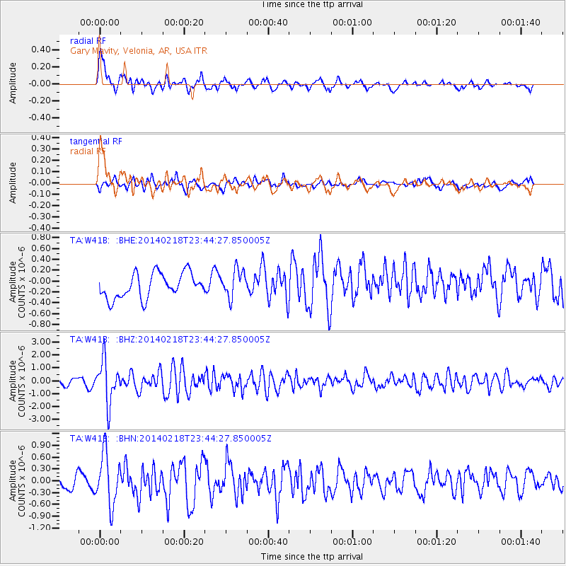
W41B Gary Mavity, Velonia, AR, USA - Earthquake Result Viewer
*The percent match for this event was below the threshold and hence no stack was calculated.
| Earthquake location: |
Near Coast Of Peru |
| Earthquake latitude/longitude: |
-14.2/-75.6 |
| Earthquake time(UTC): |
2014/02/18 (049) 23:35:58 GMT |
| Earthquake Depth: |
57 km |
| Earthquake Magnitude: |
6.0 MWB, 5.9 MWW, 5.9 MWC, 6.0 MWC |
| Earthquake Catalog/Contributor: |
NEIC PDE/NEIC COMCAT |
|
| Network: |
TA USArray Transportable Network (new EarthScope stations) |
| Station: |
W41B Gary Mavity, Velonia, AR, USA |
| Lat/Lon: |
35.17 N/92.25 W |
| Elevation: |
95 m |
|
| Distance: |
51.5 deg |
| Az: |
342.561 deg |
| Baz: |
159.216 deg |
| Ray Param: |
$rayparam |
*The percent match for this event was below the threshold and hence was not used in the summary stack. |
|
| Radial Match: |
79.651764 % |
| Radial Bump: |
400 |
| Transverse Match: |
57.63993 % |
| Transverse Bump: |
400 |
| SOD ConfigId: |
626651 |
| Insert Time: |
2014-04-20 20:22:13.861 +0000 |
| GWidth: |
2.5 |
| Max Bumps: |
400 |
| Tol: |
0.001 |
|
Signal To Noise
| Channel | StoN | STA | LTA |
| TA:W41B: :BHZ:20140218T23:44:27.850005Z | 9.808683 | 1.6733891E-6 | 1.7060282E-7 |
| TA:W41B: :BHN:20140218T23:44:27.850005Z | 3.3823755 | 6.6104445E-7 | 1.9543793E-7 |
| TA:W41B: :BHE:20140218T23:44:27.850005Z | 1.1309184 | 2.5808512E-7 | 2.2820845E-7 |
| Arrivals |
| Ps | |
| PpPs | |
| PsPs/PpSs | |


