You are here: Home > Network List > GS - US Geological Survey Networks Stations List
> Station DEC09 Decatur Surface Seismic Site, Decatur, IL, USA > Earthquake Result Viewer
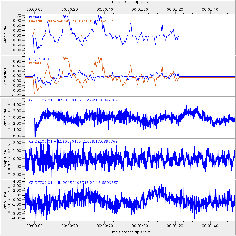
DEC09 Decatur Surface Seismic Site, Decatur, IL, USA - Earthquake Result Viewer
*The percent match for this event was below the threshold and hence no stack was calculated.
| Earthquake location: |
Southeast Of Honshu, Japan |
| Earthquake latitude/longitude: |
30.6/142.2 |
| Earthquake time(UTC): |
2015/01/05 (005) 15:16:27 GMT |
| Earthquake Depth: |
29 km |
| Earthquake Magnitude: |
5.2 MW, 4.9 MS, 5.3 mb |
| Earthquake Catalog/Contributor: |
ISC/ISC |
|
| Network: |
GS US Geological Survey Networks |
| Station: |
DEC09 Decatur Surface Seismic Site, Decatur, IL, USA |
| Lat/Lon: |
39.87 N/88.92 W |
| Elevation: |
207 m |
|
| Distance: |
95.3 deg |
| Az: |
36.989 deg |
| Baz: |
317.618 deg |
| Ray Param: |
$rayparam |
*The percent match for this event was below the threshold and hence was not used in the summary stack. |
|
| Radial Match: |
18.673752 % |
| Radial Bump: |
400 |
| Transverse Match: |
22.187288 % |
| Transverse Bump: |
400 |
| SOD ConfigId: |
3390531 |
| Insert Time: |
2019-04-15 22:29:30.098 +0000 |
| GWidth: |
2.5 |
| Max Bumps: |
400 |
| Tol: |
0.001 |
|
Signal To Noise
| Channel | StoN | STA | LTA |
| GS:DEC09:01:HHZ:20150105T15:29:17.689976Z | 1.2212836 | 8.927826E-7 | 7.310199E-7 |
| GS:DEC09:01:HHN:20150105T15:29:17.689976Z | 1.5739027 | 2.301395E-6 | 1.4622218E-6 |
| GS:DEC09:01:HHE:20150105T15:29:17.689976Z | 0.74400496 | 1.2196112E-6 | 1.6392515E-6 |
| Arrivals |
| Ps | |
| PpPs | |
| PsPs/PpSs | |


