You are here: Home > Network List > IU - Global Seismograph Network (GSN - IRIS/USGS) Stations List
> Station PMG Port Moresby, New Guinea > Earthquake Result Viewer
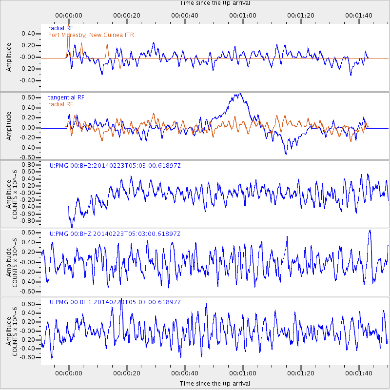
PMG Port Moresby, New Guinea - Earthquake Result Viewer
*The percent match for this event was below the threshold and hence no stack was calculated.
| Earthquake location: |
Kuril Islands |
| Earthquake latitude/longitude: |
43.5/147.8 |
| Earthquake time(UTC): |
2014/02/23 (054) 04:54:18 GMT |
| Earthquake Depth: |
20 km |
| Earthquake Magnitude: |
5.5 MWC, 5.3 MWB, 5.5 MWC |
| Earthquake Catalog/Contributor: |
NEIC PDE/NEIC COMCAT |
|
| Network: |
IU Global Seismograph Network (GSN - IRIS/USGS) |
| Station: |
PMG Port Moresby, New Guinea |
| Lat/Lon: |
9.40 S/147.16 E |
| Elevation: |
90 m |
|
| Distance: |
52.7 deg |
| Az: |
180.761 deg |
| Baz: |
0.561 deg |
| Ray Param: |
$rayparam |
*The percent match for this event was below the threshold and hence was not used in the summary stack. |
|
| Radial Match: |
50.617504 % |
| Radial Bump: |
400 |
| Transverse Match: |
55.22854 % |
| Transverse Bump: |
400 |
| SOD ConfigId: |
626651 |
| Insert Time: |
2014-04-20 20:51:42.454 +0000 |
| GWidth: |
2.5 |
| Max Bumps: |
400 |
| Tol: |
0.001 |
|
Signal To Noise
| Channel | StoN | STA | LTA |
| IU:PMG:00:BHZ:20140223T05:03:00.61897Z | 0.85229486 | 1.4597434E-7 | 1.712721E-7 |
| IU:PMG:00:BH1:20140223T05:03:00.61897Z | 1.0573933 | 2.0458673E-7 | 1.9348212E-7 |
| IU:PMG:00:BH2:20140223T05:03:00.61897Z | 0.79782456 | 2.6007734E-7 | 3.259831E-7 |
| Arrivals |
| Ps | |
| PpPs | |
| PsPs/PpSs | |


