You are here: Home > Network List > TA - USArray Transportable Network (new EarthScope stations) Stations List
> Station U53A Fall Branch, TN, USA > Earthquake Result Viewer
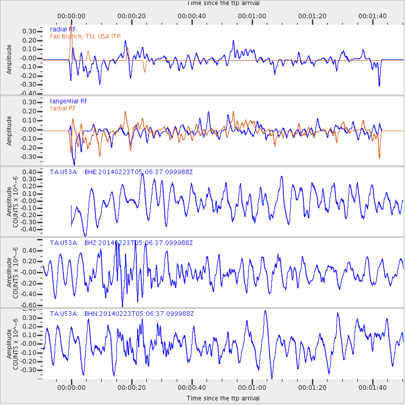
U53A Fall Branch, TN, USA - Earthquake Result Viewer
*The percent match for this event was below the threshold and hence no stack was calculated.
| Earthquake location: |
Kuril Islands |
| Earthquake latitude/longitude: |
43.5/147.8 |
| Earthquake time(UTC): |
2014/02/23 (054) 04:54:18 GMT |
| Earthquake Depth: |
20 km |
| Earthquake Magnitude: |
5.5 MWC, 5.3 MWB, 5.5 MWC |
| Earthquake Catalog/Contributor: |
NEIC PDE/NEIC COMCAT |
|
| Network: |
TA USArray Transportable Network (new EarthScope stations) |
| Station: |
U53A Fall Branch, TN, USA |
| Lat/Lon: |
36.36 N/82.58 W |
| Elevation: |
559 m |
|
| Distance: |
88.3 deg |
| Az: |
38.445 deg |
| Baz: |
325.914 deg |
| Ray Param: |
$rayparam |
*The percent match for this event was below the threshold and hence was not used in the summary stack. |
|
| Radial Match: |
44.222622 % |
| Radial Bump: |
400 |
| Transverse Match: |
60.72662 % |
| Transverse Bump: |
400 |
| SOD ConfigId: |
626651 |
| Insert Time: |
2014-04-20 21:08:37.114 +0000 |
| GWidth: |
2.5 |
| Max Bumps: |
400 |
| Tol: |
0.001 |
|
Signal To Noise
| Channel | StoN | STA | LTA |
| TA:U53A: :BHZ:20140223T05:06:37.099988Z | 1.4250736 | 2.5310476E-7 | 1.7760819E-7 |
| TA:U53A: :BHN:20140223T05:06:37.099988Z | 1.3738439 | 1.7748413E-7 | 1.2918798E-7 |
| TA:U53A: :BHE:20140223T05:06:37.099988Z | 1.1070983 | 2.1067694E-7 | 1.902965E-7 |
| Arrivals |
| Ps | |
| PpPs | |
| PsPs/PpSs | |


