You are here: Home > Network List > TA - USArray Transportable Network (new EarthScope stations) Stations List
> Station V56A Mocksville, NC, USA > Earthquake Result Viewer
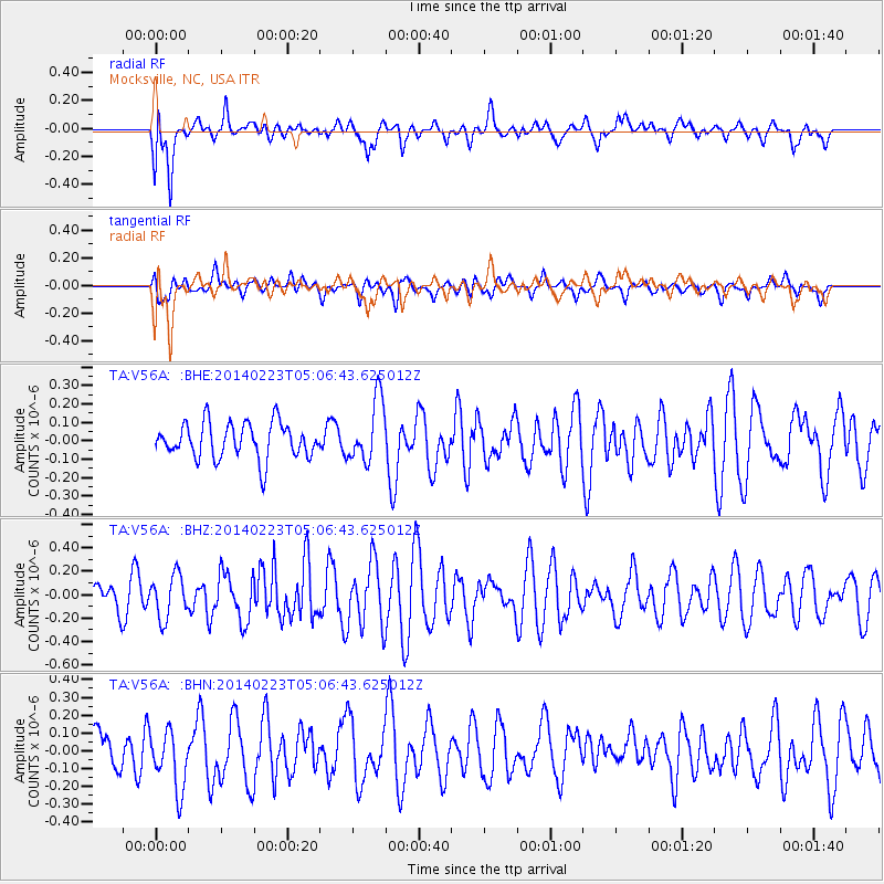
V56A Mocksville, NC, USA - Earthquake Result Viewer
*The percent match for this event was below the threshold and hence no stack was calculated.
| Earthquake location: |
Kuril Islands |
| Earthquake latitude/longitude: |
43.5/147.8 |
| Earthquake time(UTC): |
2014/02/23 (054) 04:54:18 GMT |
| Earthquake Depth: |
20 km |
| Earthquake Magnitude: |
5.5 MWC, 5.3 MWB, 5.5 MWC |
| Earthquake Catalog/Contributor: |
NEIC PDE/NEIC COMCAT |
|
| Network: |
TA USArray Transportable Network (new EarthScope stations) |
| Station: |
V56A Mocksville, NC, USA |
| Lat/Lon: |
35.81 N/80.50 W |
| Elevation: |
237 m |
|
| Distance: |
89.7 deg |
| Az: |
37.345 deg |
| Baz: |
327.114 deg |
| Ray Param: |
$rayparam |
*The percent match for this event was below the threshold and hence was not used in the summary stack. |
|
| Radial Match: |
61.60741 % |
| Radial Bump: |
400 |
| Transverse Match: |
53.22632 % |
| Transverse Bump: |
400 |
| SOD ConfigId: |
626651 |
| Insert Time: |
2014-04-20 21:08:55.429 +0000 |
| GWidth: |
2.5 |
| Max Bumps: |
400 |
| Tol: |
0.001 |
|
Signal To Noise
| Channel | StoN | STA | LTA |
| TA:V56A: :BHZ:20140223T05:06:43.625012Z | 1.5735967 | 1.8193163E-7 | 1.1561516E-7 |
| TA:V56A: :BHN:20140223T05:06:43.625012Z | 1.8412088 | 1.6828164E-7 | 9.1397375E-8 |
| TA:V56A: :BHE:20140223T05:06:43.625012Z | 1.7450691 | 1.6861205E-7 | 9.662199E-8 |
| Arrivals |
| Ps | |
| PpPs | |
| PsPs/PpSs | |


