You are here: Home > Network List > TA - USArray Transportable Network (new EarthScope stations) Stations List
> Station J01E Myrtle Point, OR, USA > Earthquake Result Viewer
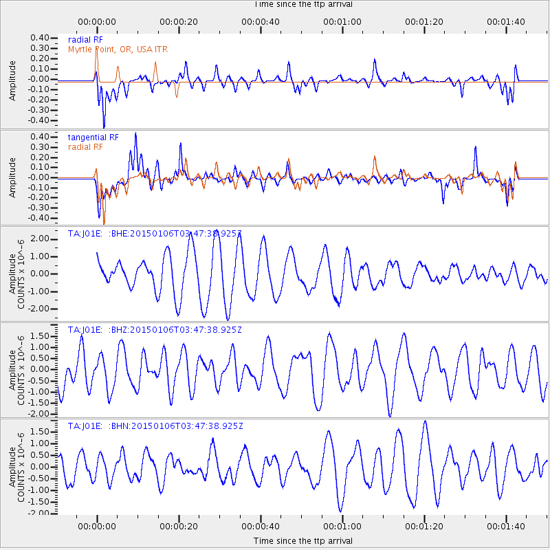
J01E Myrtle Point, OR, USA - Earthquake Result Viewer
*The percent match for this event was below the threshold and hence no stack was calculated.
| Earthquake location: |
South Of Kermadec Islands |
| Earthquake latitude/longitude: |
-33.2/-179.1 |
| Earthquake time(UTC): |
2015/01/06 (006) 03:35:09 GMT |
| Earthquake Depth: |
45 km |
| Earthquake Magnitude: |
4.8 mb, 3.7 MS, 4.8 mb |
| Earthquake Catalog/Contributor: |
ISC/ISC |
|
| Network: |
TA USArray Transportable Network (new EarthScope stations) |
| Station: |
J01E Myrtle Point, OR, USA |
| Lat/Lon: |
43.16 N/123.93 W |
| Elevation: |
128 m |
|
| Distance: |
91.2 deg |
| Az: |
36.939 deg |
| Baz: |
223.521 deg |
| Ray Param: |
$rayparam |
*The percent match for this event was below the threshold and hence was not used in the summary stack. |
|
| Radial Match: |
47.185833 % |
| Radial Bump: |
400 |
| Transverse Match: |
49.059967 % |
| Transverse Bump: |
400 |
| SOD ConfigId: |
3390531 |
| Insert Time: |
2019-04-15 22:43:59.708 +0000 |
| GWidth: |
2.5 |
| Max Bumps: |
400 |
| Tol: |
0.001 |
|
Signal To Noise
| Channel | StoN | STA | LTA |
| TA:J01E: :BHZ:20150106T03:47:38.925Z | 0.86201334 | 7.2365697E-7 | 8.394963E-7 |
| TA:J01E: :BHN:20150106T03:47:38.925Z | 1.0636368 | 4.9826025E-7 | 4.684496E-7 |
| TA:J01E: :BHE:20150106T03:47:38.925Z | 1.8591295 | 1.8456482E-6 | 9.927485E-7 |
| Arrivals |
| Ps | |
| PpPs | |
| PsPs/PpSs | |


