You are here: Home > Network List > II - Global Seismograph Network (GSN - IRIS/IDA) Stations List
> Station BRVK Borovoye, Kazakhstan > Earthquake Result Viewer
BRVK Borovoye, Kazakhstan - Earthquake Result Viewer
| Earthquake location: |
Northwest Of Kuril Islands |
| Earthquake latitude/longitude: |
47.8/146.2 |
| Earthquake time(UTC): |
2002/11/17 (321) 04:53:53 GMT |
| Earthquake Depth: |
459 km |
| Earthquake Magnitude: |
7.3 MW, 7.3 MW |
| Earthquake Catalog/Contributor: |
WHDF/NEIC |
|
| Network: |
II Global Seismograph Network (GSN - IRIS/IDA) |
| Station: |
BRVK Borovoye, Kazakhstan |
| Lat/Lon: |
53.06 N/70.28 E |
| Elevation: |
330 m |
|
| Distance: |
46.5 deg |
| Az: |
306.222 deg |
| Baz: |
64.249 deg |
| Ray Param: |
0.06852538 |
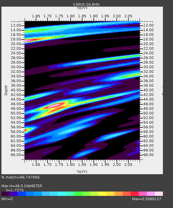
| Estimated Moho Depth: |
46.5 km |
| Estimated Crust Vp/Vs: |
1.73 |
| Assumed Crust Vp: |
6.552 km/s |
| Estimated Crust Vs: |
3.793 km/s |
| Estimated Crust Poisson's Ratio: |
0.25 |
|
| Radial Match: |
96.747856 % |
| Radial Bump: |
243 |
| Transverse Match: |
89.13709 % |
| Transverse Bump: |
400 |
| SOD ConfigId: |
4714 |
| Insert Time: |
2010-03-01 18:50:10.064 +0000 |
| GWidth: |
2.5 |
| Max Bumps: |
400 |
| Tol: |
0.001 |
|
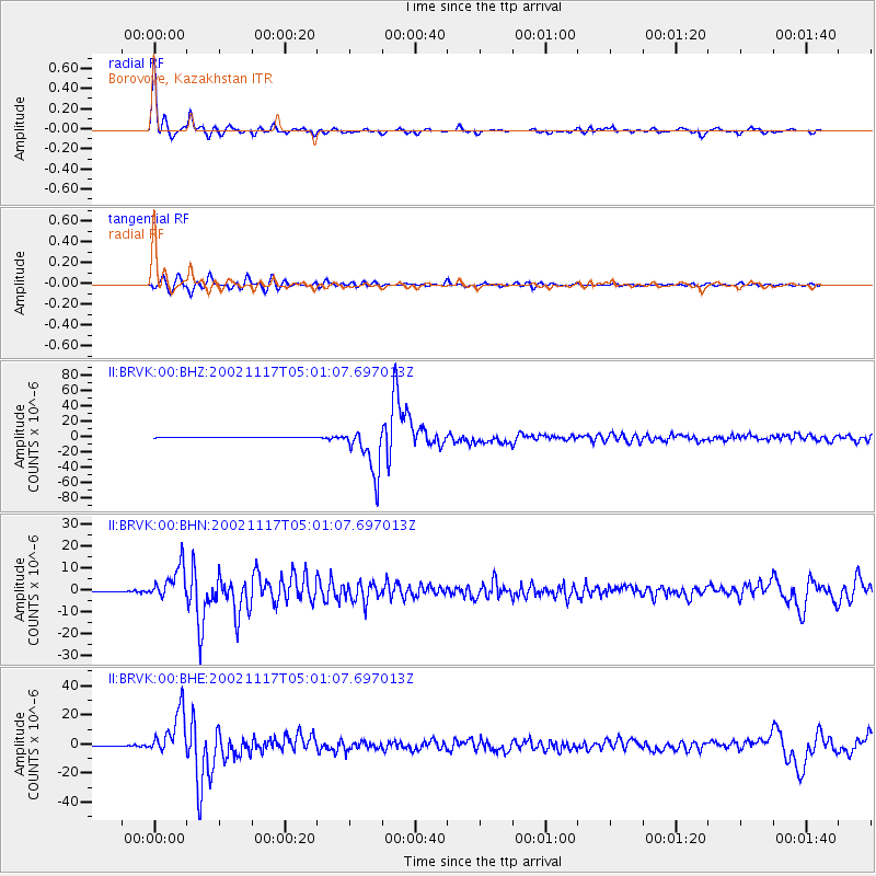
Signal To Noise
| Channel | StoN | STA | LTA |
| II:BRVK:00:BHN:20021117T05:01:07.697013Z | 131.52428 | 7.571501E-6 | 5.7567327E-8 |
| II:BRVK:00:BHE:20021117T05:01:07.697013Z | 98.76076 | 1.5244871E-5 | 1.5436163E-7 |
| II:BRVK:00:BHZ:20021117T05:01:07.697013Z | 127.62713 | 3.1343036E-5 | 2.4558287E-7 |
| Arrivals |
| Ps | 5.5 SECOND |
| PpPs | 18 SECOND |
| PsPs/PpSs | 24 SECOND |


