You are here: Home > Network List > GS - US Geological Survey Networks Stations List
> Station KAN10 Keim Farm > Earthquake Result Viewer
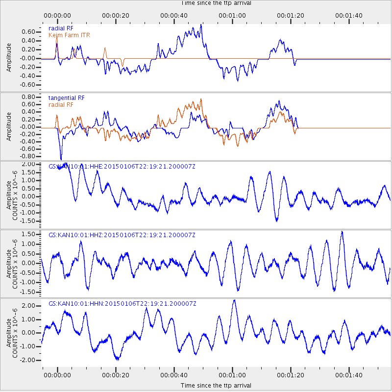
KAN10 Keim Farm - Earthquake Result Viewer
*The percent match for this event was below the threshold and hence no stack was calculated.
| Earthquake location: |
Off East Coast Of Kamchatka |
| Earthquake latitude/longitude: |
55.2/163.4 |
| Earthquake time(UTC): |
2015/01/06 (006) 22:09:16 GMT |
| Earthquake Depth: |
39 km |
| Earthquake Magnitude: |
5.5 MW, 5.2 mb, 5.5 MS |
| Earthquake Catalog/Contributor: |
ISC/ISC |
|
| Network: |
GS US Geological Survey Networks |
| Station: |
KAN10 Keim Farm |
| Lat/Lon: |
37.12 N/98.10 W |
| Elevation: |
417 m |
|
| Distance: |
64.9 deg |
| Az: |
60.803 deg |
| Baz: |
321.2 deg |
| Ray Param: |
$rayparam |
*The percent match for this event was below the threshold and hence was not used in the summary stack. |
|
| Radial Match: |
39.49672 % |
| Radial Bump: |
400 |
| Transverse Match: |
55.93897 % |
| Transverse Bump: |
400 |
| SOD ConfigId: |
3390531 |
| Insert Time: |
2019-04-15 22:52:17.268 +0000 |
| GWidth: |
2.5 |
| Max Bumps: |
400 |
| Tol: |
0.001 |
|
Signal To Noise
| Channel | StoN | STA | LTA |
| GS:KAN10:01:HHZ:20150106T22:19:21.200007Z | 1.0761462 | 4.699439E-7 | 4.3669147E-7 |
| GS:KAN10:01:HHN:20150106T22:19:21.200007Z | 1.5019143 | 1.3535005E-6 | 9.0118357E-7 |
| GS:KAN10:01:HHE:20150106T22:19:21.200007Z | 1.7437061 | 1.3299732E-6 | 7.627279E-7 |
| Arrivals |
| Ps | |
| PpPs | |
| PsPs/PpSs | |


