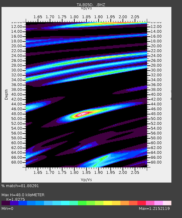
B05D Stanwood, WA, USA - Earthquake Result Viewer

Earthquake location: Fox Islands, Aleutian Islands
Earthquake latitude/longitude: 53.6/-171.8
Earthquake time(UTC): 2014/02/26 (057) 21:13:40 GMT
Earthquake Depth: 265 km
Earthquake Magnitude: 6.1 MWW, 5.9 MI, 5.9 ML, 6.1 MWC, 6.1 MWB, 6.2 MWC
Earthquake Catalog/Contributor: NEIC PDE/NEIC COMCAT
Network: TA USArray Transportable Network (new EarthScope stations)
Station: B05D Stanwood, WA, USA
Lat/Lon: 48.26 N/122.10 W
Elevation: 153 m
Distance: 31.3 deg
Az: 79.281 deg
Baz: 298.8 deg
Ray Param: 0.07830426
Estimated Moho Depth: 48.0 km
Estimated Crust Vp/Vs: 1.83
Assumed Crust Vp: 6.566 km/s
Estimated Crust Vs: 3.593 km/s
Estimated Crust Poisson's Ratio: 0.29
Radial Match: 81.88291 %
Radial Bump: 400
Transverse Match: 62.05452 %
Transverse Bump: 400
SOD ConfigId: 626651
Insert Time: 2014-04-20 22:13:06.955 +0000
GWidth: 2.5
Max Bumps: 400
Tol: 0.001

Signal To Noise

ChannelStoNSTALTA
TA:B05D: :BHZ:20140226T21:19:05.000015Z5.54434972.12923E-63.8403604E-7
TA:B05D: :BHN:20140226T21:19:05.000015Z2.3142946.8851546E-72.975056E-7
TA:B05D: :BHE:20140226T21:19:05.000015Z2.2674387.7860346E-73.4338467E-7
Arrivals
Ps6.5 SECOND
PpPs19 SECOND
PsPs/PpSs26 SECOND