You are here: Home > Network List > TA - USArray Transportable Network (new EarthScope stations) Stations List
> Station L58A Harry Jones Memorial, Binghamton, NY, USA > Earthquake Result Viewer
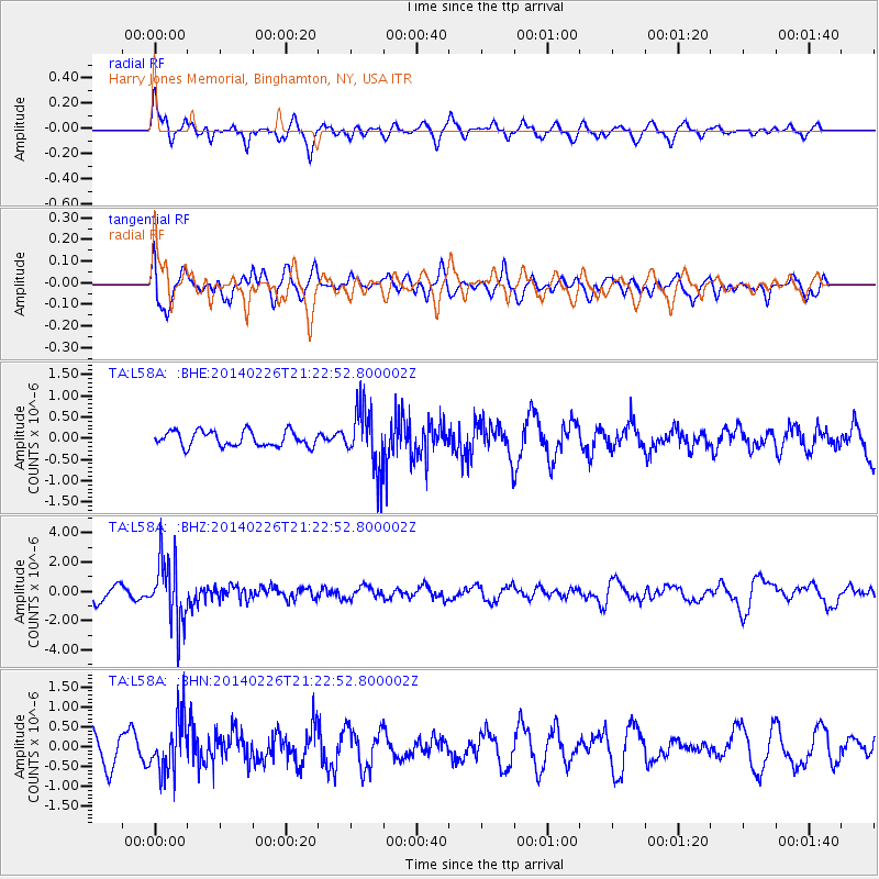
L58A Harry Jones Memorial, Binghamton, NY, USA - Earthquake Result Viewer
*The percent match for this event was below the threshold and hence no stack was calculated.
| Earthquake location: |
Fox Islands, Aleutian Islands |
| Earthquake latitude/longitude: |
53.6/-171.8 |
| Earthquake time(UTC): |
2014/02/26 (057) 21:13:40 GMT |
| Earthquake Depth: |
265 km |
| Earthquake Magnitude: |
6.1 MWW, 5.9 MI, 5.9 ML, 6.1 MWC, 6.1 MWB, 6.2 MWC |
| Earthquake Catalog/Contributor: |
NEIC PDE/NEIC COMCAT |
|
| Network: |
TA USArray Transportable Network (new EarthScope stations) |
| Station: |
L58A Harry Jones Memorial, Binghamton, NY, USA |
| Lat/Lon: |
42.04 N/75.85 W |
| Elevation: |
447 m |
|
| Distance: |
60.7 deg |
| Az: |
58.171 deg |
| Baz: |
317.175 deg |
| Ray Param: |
$rayparam |
*The percent match for this event was below the threshold and hence was not used in the summary stack. |
|
| Radial Match: |
57.038723 % |
| Radial Bump: |
389 |
| Transverse Match: |
68.80613 % |
| Transverse Bump: |
400 |
| SOD ConfigId: |
626651 |
| Insert Time: |
2014-04-20 22:20:42.535 +0000 |
| GWidth: |
2.5 |
| Max Bumps: |
400 |
| Tol: |
0.001 |
|
Signal To Noise
| Channel | StoN | STA | LTA |
| TA:L58A: :BHZ:20140226T21:22:52.800002Z | 5.7336807 | 2.2200302E-6 | 3.871911E-7 |
| TA:L58A: :BHN:20140226T21:22:52.800002Z | 2.2428763 | 6.779944E-7 | 3.0228793E-7 |
| TA:L58A: :BHE:20140226T21:22:52.800002Z | 3.9459643 | 7.0307806E-7 | 1.7817649E-7 |
| Arrivals |
| Ps | |
| PpPs | |
| PsPs/PpSs | |


