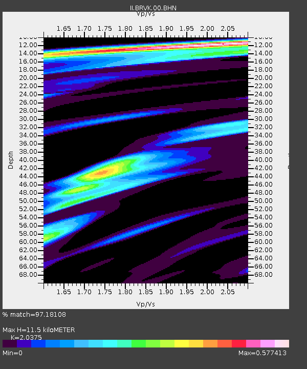
BRVK Borovoye, Kazakhstan - Earthquake Result Viewer
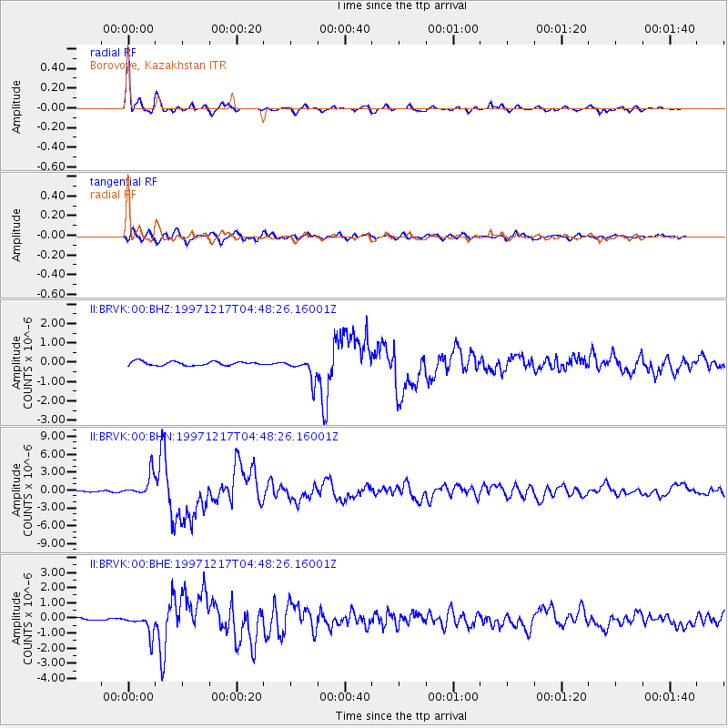
Earthquake location: Rat Islands, Aleutian Islands
Earthquake latitude/longitude: 51.2/178.9
Earthquake time(UTC): 1997/12/17 (351) 04:38:51 GMT
Earthquake Depth: 20 km
Earthquake Magnitude: 5.8 MB, 6.5 MS, 6.7 UNKNOWN, 6.1 ME
Earthquake Catalog/Contributor: WHDF/NEIC
Network: II Global Seismograph Network (GSN - IRIS/IDA)
Station: BRVK Borovoye, Kazakhstan
Lat/Lon: 53.06 N/70.28 E
Elevation: 330 m
Distance: 60.1 deg
Az: 318.704 deg
Baz: 43.481 deg
Ray Param: 0.06173392
Estimated Moho Depth: 11.5 km
Estimated Crust Vp/Vs: 2.04
Assumed Crust Vp: 6.552 km/s
Estimated Crust Vs: 3.216 km/s
Estimated Crust Poisson's Ratio: 0.34
Radial Match: 97.18108 %
Radial Bump: 315
Transverse Match: 86.360374 %
Transverse Bump: 400
SOD ConfigId: 4480
Insert Time: 2010-03-01 18:51:20.986 +0000
GWidth: 2.5
Max Bumps: 400
Tol: 0.001

Signal To Noise

ChannelStoNSTALTA
II:BRVK:00:BHN:19971217T04:48:26.16001Z17.4995671.9536558E-61.1164023E-7
II:BRVK:00:BHE:19971217T04:48:26.16001Z6.6428786.8692185E-71.0340727E-7
II:BRVK:00:BHZ:19971217T04:48:26.16001Z5.8730055.7871137E-79.853753E-8
Arrivals
Ps1.9 SECOND
PpPs5.1 SECOND
PsPs/PpSs7.0 SECOND