You are here: Home > Network List > CI - Caltech Regional Seismic Network Stations List
> Station MPM Manuel Prospect Mine, California, USA > Earthquake Result Viewer
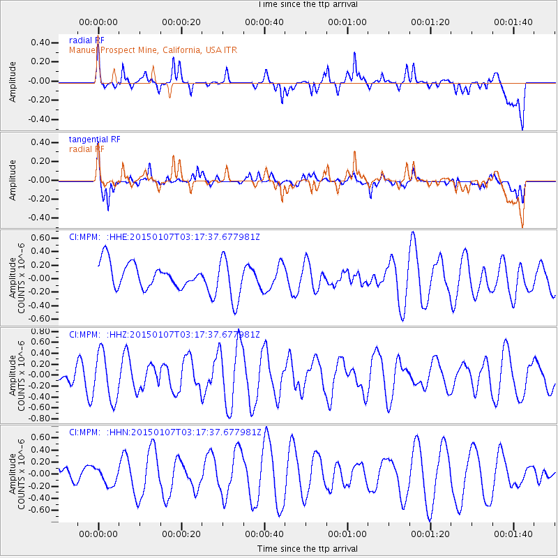
MPM Manuel Prospect Mine, California, USA - Earthquake Result Viewer
*The percent match for this event was below the threshold and hence no stack was calculated.
| Earthquake location: |
Southeast Of Easter Island |
| Earthquake latitude/longitude: |
-35.7/-103.7 |
| Earthquake time(UTC): |
2015/01/07 (007) 03:06:41 GMT |
| Earthquake Depth: |
10 km |
| Earthquake Magnitude: |
6.0 MW, 5.2 mb, 5.5 MS |
| Earthquake Catalog/Contributor: |
ISC/ISC |
|
| Network: |
CI Caltech Regional Seismic Network |
| Station: |
MPM Manuel Prospect Mine, California, USA |
| Lat/Lon: |
36.06 N/117.49 W |
| Elevation: |
185 m |
|
| Distance: |
72.6 deg |
| Az: |
348.31 deg |
| Baz: |
168.259 deg |
| Ray Param: |
$rayparam |
*The percent match for this event was below the threshold and hence was not used in the summary stack. |
|
| Radial Match: |
70.88775 % |
| Radial Bump: |
400 |
| Transverse Match: |
59.811 % |
| Transverse Bump: |
389 |
| SOD ConfigId: |
3390531 |
| Insert Time: |
2019-04-15 23:03:03.469 +0000 |
| GWidth: |
2.5 |
| Max Bumps: |
400 |
| Tol: |
0.001 |
|
Signal To Noise
| Channel | StoN | STA | LTA |
| CI:MPM: :HHZ:20150107T03:17:37.677981Z | 1.8612612 | 4.382199E-7 | 2.3544244E-7 |
| CI:MPM: :HHN:20150107T03:17:37.677981Z | 0.4139269 | 1.2717982E-7 | 3.0725187E-7 |
| CI:MPM: :HHE:20150107T03:17:37.677981Z | 1.9407508 | 3.364296E-7 | 1.7335022E-7 |
| Arrivals |
| Ps | |
| PpPs | |
| PsPs/PpSs | |


