You are here: Home > Network List > TA - USArray Transportable Network (new EarthScope stations) Stations List
> Station S56A Natural Bridge, VA, USA > Earthquake Result Viewer
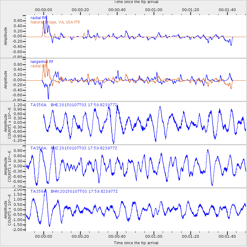
S56A Natural Bridge, VA, USA - Earthquake Result Viewer
*The percent match for this event was below the threshold and hence no stack was calculated.
| Earthquake location: |
Southeast Of Easter Island |
| Earthquake latitude/longitude: |
-35.7/-103.7 |
| Earthquake time(UTC): |
2015/01/07 (007) 03:06:41 GMT |
| Earthquake Depth: |
10 km |
| Earthquake Magnitude: |
6.0 MW, 5.2 mb, 5.5 MS |
| Earthquake Catalog/Contributor: |
ISC/ISC |
|
| Network: |
TA USArray Transportable Network (new EarthScope stations) |
| Station: |
S56A Natural Bridge, VA, USA |
| Lat/Lon: |
37.68 N/79.57 W |
| Elevation: |
449 m |
|
| Distance: |
76.4 deg |
| Az: |
19.49 deg |
| Baz: |
200.01 deg |
| Ray Param: |
$rayparam |
*The percent match for this event was below the threshold and hence was not used in the summary stack. |
|
| Radial Match: |
75.87071 % |
| Radial Bump: |
400 |
| Transverse Match: |
67.675026 % |
| Transverse Bump: |
400 |
| SOD ConfigId: |
3390531 |
| Insert Time: |
2019-04-15 23:07:09.538 +0000 |
| GWidth: |
2.5 |
| Max Bumps: |
400 |
| Tol: |
0.001 |
|
Signal To Noise
| Channel | StoN | STA | LTA |
| TA:S56A: :BHZ:20150107T03:17:59.823977Z | 1.1850605 | 6.415266E-7 | 5.41345E-7 |
| TA:S56A: :BHN:20150107T03:17:59.823977Z | 1.9872228 | 1.1861837E-6 | 5.9690524E-7 |
| TA:S56A: :BHE:20150107T03:17:59.823977Z | 0.8357936 | 3.7646922E-7 | 4.5043325E-7 |
| Arrivals |
| Ps | |
| PpPs | |
| PsPs/PpSs | |


