You are here: Home > Network List > TA - USArray Transportable Network (new EarthScope stations) Stations List
> Station W56A Indian Trail, NC, USA > Earthquake Result Viewer
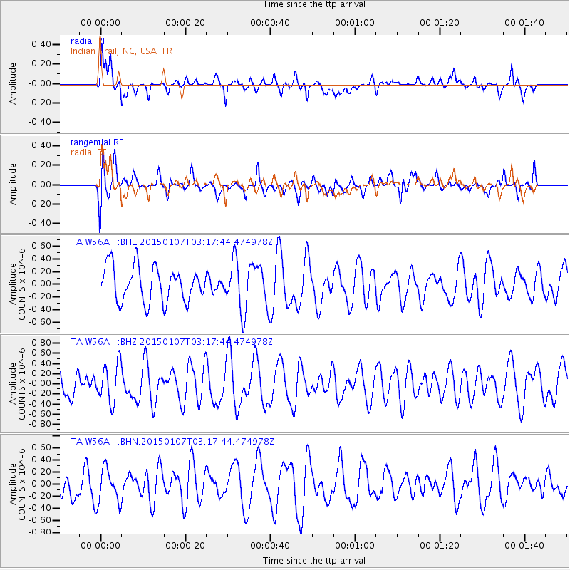
W56A Indian Trail, NC, USA - Earthquake Result Viewer
*The percent match for this event was below the threshold and hence no stack was calculated.
| Earthquake location: |
Southeast Of Easter Island |
| Earthquake latitude/longitude: |
-35.7/-103.7 |
| Earthquake time(UTC): |
2015/01/07 (007) 03:06:41 GMT |
| Earthquake Depth: |
10 km |
| Earthquake Magnitude: |
6.0 MW, 5.2 mb, 5.5 MS |
| Earthquake Catalog/Contributor: |
ISC/ISC |
|
| Network: |
TA USArray Transportable Network (new EarthScope stations) |
| Station: |
W56A Indian Trail, NC, USA |
| Lat/Lon: |
35.13 N/80.58 W |
| Elevation: |
177 m |
|
| Distance: |
73.7 deg |
| Az: |
19.577 deg |
| Baz: |
199.431 deg |
| Ray Param: |
$rayparam |
*The percent match for this event was below the threshold and hence was not used in the summary stack. |
|
| Radial Match: |
65.29983 % |
| Radial Bump: |
400 |
| Transverse Match: |
61.55226 % |
| Transverse Bump: |
400 |
| SOD ConfigId: |
3390531 |
| Insert Time: |
2019-04-15 23:07:16.210 +0000 |
| GWidth: |
2.5 |
| Max Bumps: |
400 |
| Tol: |
0.001 |
|
Signal To Noise
| Channel | StoN | STA | LTA |
| TA:W56A: :BHZ:20150107T03:17:44.474978Z | 1.1034254 | 3.8531687E-7 | 3.4920063E-7 |
| TA:W56A: :BHN:20150107T03:17:44.474978Z | 1.1580741 | 2.9079115E-7 | 2.510989E-7 |
| TA:W56A: :BHE:20150107T03:17:44.474978Z | 1.4748075 | 4.0550512E-7 | 2.749546E-7 |
| Arrivals |
| Ps | |
| PpPs | |
| PsPs/PpSs | |


