You are here: Home > Network List > UW - Pacific Northwest Regional Seismic Network Stations List
> Station PASS Maple Falls, WA, USA > Earthquake Result Viewer
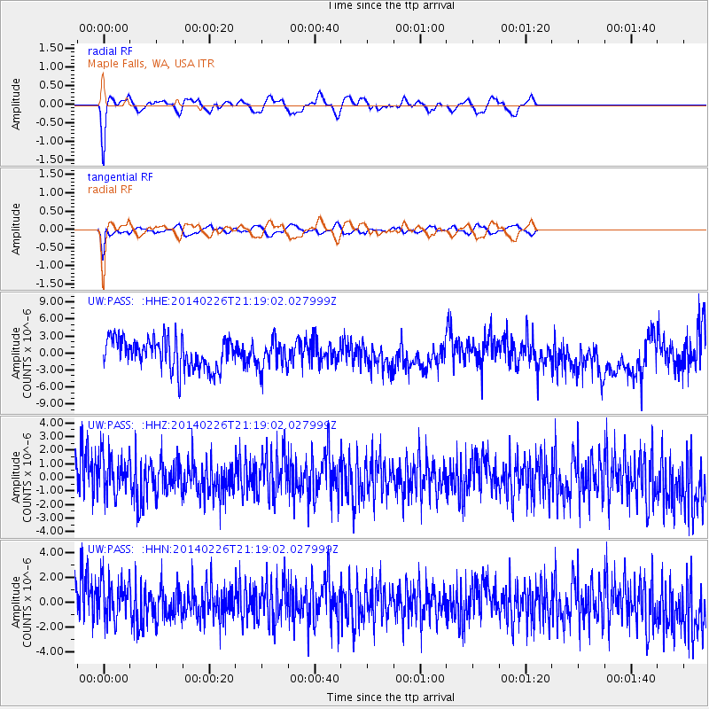
PASS Maple Falls, WA, USA - Earthquake Result Viewer
*The percent match for this event was below the threshold and hence no stack was calculated.
| Earthquake location: |
Fox Islands, Aleutian Islands |
| Earthquake latitude/longitude: |
53.6/-171.8 |
| Earthquake time(UTC): |
2014/02/26 (057) 21:13:40 GMT |
| Earthquake Depth: |
265 km |
| Earthquake Magnitude: |
6.1 MWW, 5.9 MI, 5.9 ML, 6.1 MWC, 6.1 MWB, 6.2 MWC |
| Earthquake Catalog/Contributor: |
NEIC PDE/NEIC COMCAT |
|
| Network: |
UW Pacific Northwest Regional Seismic Network |
| Station: |
PASS Maple Falls, WA, USA |
| Lat/Lon: |
49.00 N/122.09 W |
| Elevation: |
174 m |
|
| Distance: |
30.9 deg |
| Az: |
78.021 deg |
| Baz: |
297.729 deg |
| Ray Param: |
$rayparam |
*The percent match for this event was below the threshold and hence was not used in the summary stack. |
|
| Radial Match: |
60.925114 % |
| Radial Bump: |
400 |
| Transverse Match: |
65.12794 % |
| Transverse Bump: |
400 |
| SOD ConfigId: |
626651 |
| Insert Time: |
2014-04-20 22:34:29.272 +0000 |
| GWidth: |
2.5 |
| Max Bumps: |
400 |
| Tol: |
0.001 |
|
Signal To Noise
| Channel | StoN | STA | LTA |
| UW:PASS: :HHZ:20140226T21:19:02.027999Z | 0.5319266 | 1.9528625E-6 | 3.671301E-6 |
| UW:PASS: :HHN:20140226T21:19:02.027999Z | 0.5484709 | 2.1453766E-6 | 3.9115594E-6 |
| UW:PASS: :HHE:20140226T21:19:02.027999Z | 0.91430926 | 2.4618432E-6 | 2.6925716E-6 |
| Arrivals |
| Ps | |
| PpPs | |
| PsPs/PpSs | |


