You are here: Home > Network List > TA - USArray Transportable Network (new EarthScope stations) Stations List
> Station G59A Clarenceville, QC, USA > Earthquake Result Viewer
G59A Clarenceville, QC, USA - Earthquake Result Viewer
*The percent match for this event was below the threshold and hence no stack was calculated.
| Earthquake location: |
Bering Sea |
| Earthquake latitude/longitude: |
54.8/-172.4 |
| Earthquake time(UTC): |
2014/02/26 (057) 21:13:41 GMT |
| Earthquake Depth: |
37 km |
| Earthquake Magnitude: |
5.7 M |
| Earthquake Catalog/Contributor: |
NEIC PDE/NEIC ALERT |
|
| Network: |
TA USArray Transportable Network (new EarthScope stations) |
| Station: |
G59A Clarenceville, QC, USA |
| Lat/Lon: |
45.08 N/73.18 W |
| Elevation: |
36 m |
|
| Distance: |
59.3 deg |
| Az: |
54.395 deg |
| Baz: |
318.357 deg |
| Ray Param: |
$rayparam |
*The percent match for this event was below the threshold and hence was not used in the summary stack. |
|
| Radial Match: |
54.951828 % |
| Radial Bump: |
400 |
| Transverse Match: |
29.58802 % |
| Transverse Bump: |
400 |
| SOD ConfigId: |
626651 |
| Insert Time: |
2014-04-20 22:55:58.555 +0000 |
| GWidth: |
2.5 |
| Max Bumps: |
400 |
| Tol: |
0.001 |
|
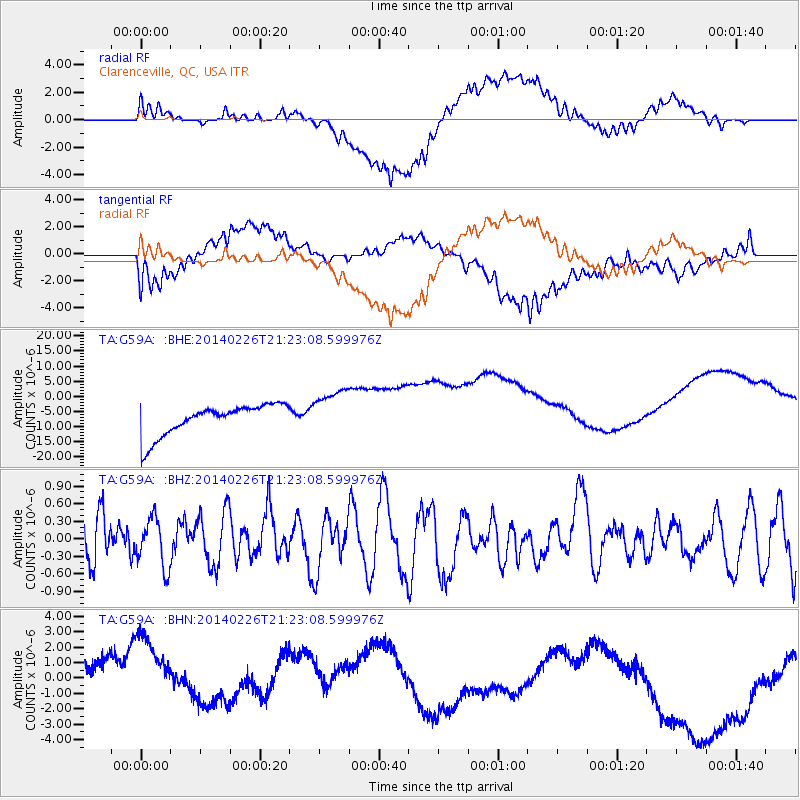
Signal To Noise
| Channel | StoN | STA | LTA |
| TA:G59A: :BHZ:20140226T21:23:08.599976Z | 0.77283704 | 4.1544243E-7 | 5.37555E-7 |
| TA:G59A: :BHN:20140226T21:23:08.599976Z | 1.0396347 | 4.786652E-6 | 4.604167E-6 |
| TA:G59A: :BHE:20140226T21:23:08.599976Z | 1.532764 | 7.744599E-6 | 5.052702E-6 |
| Arrivals |
| Ps | |
| PpPs | |
| PsPs/PpSs | |


