You are here: Home > Network List > TA - USArray Transportable Network (new EarthScope stations) Stations List
> Station M47A Cromwell, IN, USA > Earthquake Result Viewer
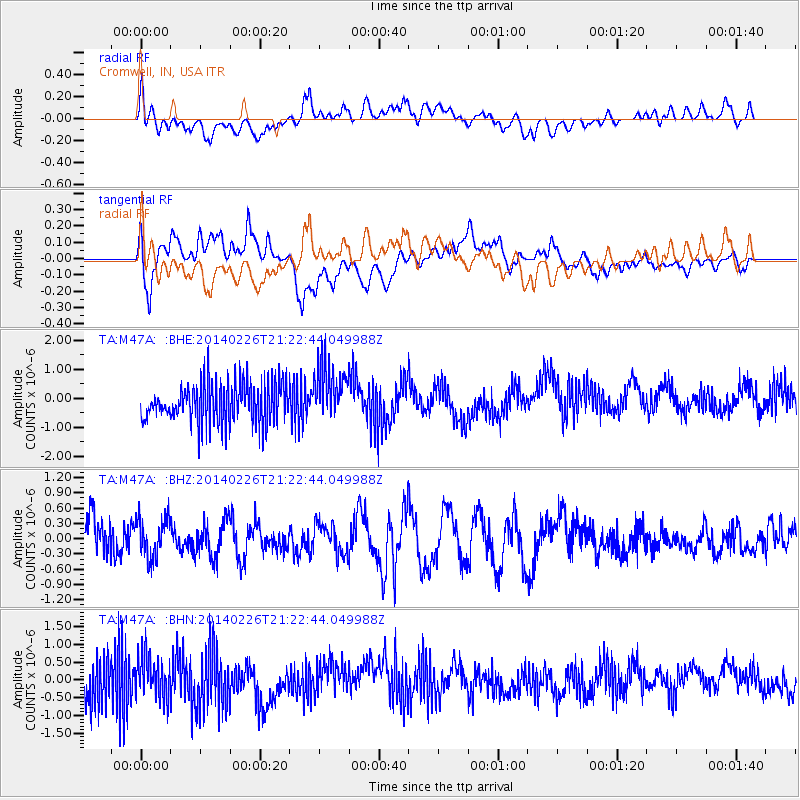
M47A Cromwell, IN, USA - Earthquake Result Viewer
*The percent match for this event was below the threshold and hence no stack was calculated.
| Earthquake location: |
Bering Sea |
| Earthquake latitude/longitude: |
54.8/-172.4 |
| Earthquake time(UTC): |
2014/02/26 (057) 21:13:41 GMT |
| Earthquake Depth: |
37 km |
| Earthquake Magnitude: |
5.7 M |
| Earthquake Catalog/Contributor: |
NEIC PDE/NEIC ALERT |
|
| Network: |
TA USArray Transportable Network (new EarthScope stations) |
| Station: |
M47A Cromwell, IN, USA |
| Lat/Lon: |
41.36 N/85.62 W |
| Elevation: |
283 m |
|
| Distance: |
55.8 deg |
| Az: |
65.262 deg |
| Baz: |
315.685 deg |
| Ray Param: |
$rayparam |
*The percent match for this event was below the threshold and hence was not used in the summary stack. |
|
| Radial Match: |
51.712463 % |
| Radial Bump: |
400 |
| Transverse Match: |
57.110485 % |
| Transverse Bump: |
400 |
| SOD ConfigId: |
626651 |
| Insert Time: |
2014-04-20 22:58:19.159 +0000 |
| GWidth: |
2.5 |
| Max Bumps: |
400 |
| Tol: |
0.001 |
|
Signal To Noise
| Channel | StoN | STA | LTA |
| TA:M47A: :BHZ:20140226T21:22:44.049988Z | 0.5613867 | 3.845917E-7 | 6.8507444E-7 |
| TA:M47A: :BHN:20140226T21:22:44.049988Z | 1.0603795 | 5.8518907E-7 | 5.518676E-7 |
| TA:M47A: :BHE:20140226T21:22:44.049988Z | 1.4366113 | 9.74424E-7 | 6.7827955E-7 |
| Arrivals |
| Ps | |
| PpPs | |
| PsPs/PpSs | |


