You are here: Home > Network List > UW - Pacific Northwest Regional Seismic Network Stations List
> Station LCCR Mulino, OR, USA > Earthquake Result Viewer
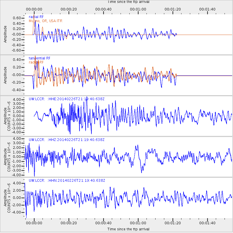
LCCR Mulino, OR, USA - Earthquake Result Viewer
*The percent match for this event was below the threshold and hence no stack was calculated.
| Earthquake location: |
Bering Sea |
| Earthquake latitude/longitude: |
54.8/-172.4 |
| Earthquake time(UTC): |
2014/02/26 (057) 21:13:41 GMT |
| Earthquake Depth: |
37 km |
| Earthquake Magnitude: |
5.7 M |
| Earthquake Catalog/Contributor: |
NEIC PDE/NEIC ALERT |
|
| Network: |
UW Pacific Northwest Regional Seismic Network |
| Station: |
LCCR Mulino, OR, USA |
| Lat/Lon: |
45.21 N/122.48 W |
| Elevation: |
273 m |
|
| Distance: |
32.8 deg |
| Az: |
85.963 deg |
| Baz: |
305.212 deg |
| Ray Param: |
$rayparam |
*The percent match for this event was below the threshold and hence was not used in the summary stack. |
|
| Radial Match: |
61.491184 % |
| Radial Bump: |
400 |
| Transverse Match: |
56.68645 % |
| Transverse Bump: |
400 |
| SOD ConfigId: |
626651 |
| Insert Time: |
2014-04-20 23:03:54.400 +0000 |
| GWidth: |
2.5 |
| Max Bumps: |
400 |
| Tol: |
0.001 |
|
Signal To Noise
| Channel | StoN | STA | LTA |
| UW:LCCR: :HHZ:20140226T21:19:40.638Z | 0.9578844 | 1.3945825E-6 | 1.4558985E-6 |
| UW:LCCR: :HHN:20140226T21:19:40.638Z | 1.38729 | 1.4914257E-6 | 1.0750641E-6 |
| UW:LCCR: :HHE:20140226T21:19:40.638Z | 1.6975528 | 2.0899913E-6 | 1.231179E-6 |
| Arrivals |
| Ps | |
| PpPs | |
| PsPs/PpSs | |


