You are here: Home > Network List > UW - Pacific Northwest Regional Seismic Network Stations List
> Station MRBL Marblemount, WA, USA > Earthquake Result Viewer
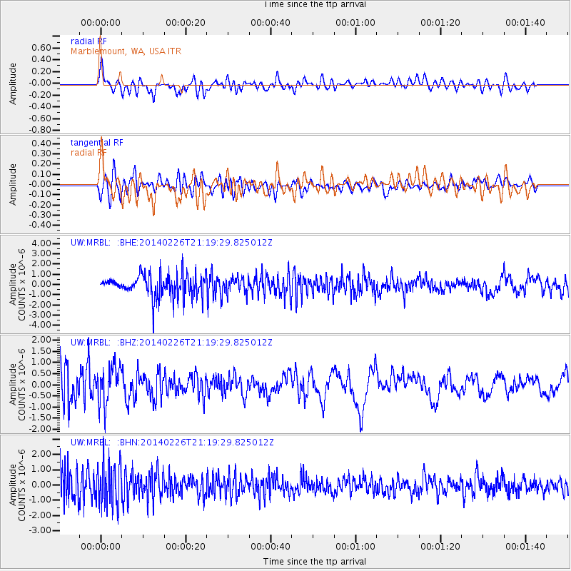
MRBL Marblemount, WA, USA - Earthquake Result Viewer
*The percent match for this event was below the threshold and hence no stack was calculated.
| Earthquake location: |
Bering Sea |
| Earthquake latitude/longitude: |
54.8/-172.4 |
| Earthquake time(UTC): |
2014/02/26 (057) 21:13:41 GMT |
| Earthquake Depth: |
37 km |
| Earthquake Magnitude: |
5.7 M |
| Earthquake Catalog/Contributor: |
NEIC PDE/NEIC ALERT |
|
| Network: |
UW Pacific Northwest Regional Seismic Network |
| Station: |
MRBL Marblemount, WA, USA |
| Lat/Lon: |
48.52 N/121.48 W |
| Elevation: |
75 m |
|
| Distance: |
31.6 deg |
| Az: |
80.052 deg |
| Baz: |
300.932 deg |
| Ray Param: |
$rayparam |
*The percent match for this event was below the threshold and hence was not used in the summary stack. |
|
| Radial Match: |
64.60047 % |
| Radial Bump: |
400 |
| Transverse Match: |
57.85519 % |
| Transverse Bump: |
400 |
| SOD ConfigId: |
626651 |
| Insert Time: |
2014-04-20 23:04:00.668 +0000 |
| GWidth: |
2.5 |
| Max Bumps: |
400 |
| Tol: |
0.001 |
|
Signal To Noise
| Channel | StoN | STA | LTA |
| UW:MRBL: :BHZ:20140226T21:19:29.825012Z | 0.7193602 | 8.673836E-7 | 1.205771E-6 |
| UW:MRBL: :BHN:20140226T21:19:29.825012Z | 1.5076944 | 1.4266462E-6 | 9.4624363E-7 |
| UW:MRBL: :BHE:20140226T21:19:29.825012Z | 0.7057147 | 7.25798E-7 | 1.0284581E-6 |
| Arrivals |
| Ps | |
| PpPs | |
| PsPs/PpSs | |


