You are here: Home > Network List > TA - USArray Transportable Network (new EarthScope stations) Stations List
> Station E62A Clayton Lake, ME, USA > Earthquake Result Viewer
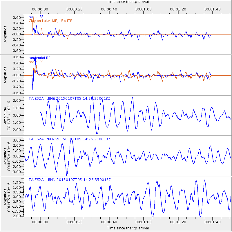
E62A Clayton Lake, ME, USA - Earthquake Result Viewer
*The percent match for this event was below the threshold and hence no stack was calculated.
| Earthquake location: |
South Of Panama |
| Earthquake latitude/longitude: |
5.8/-82.7 |
| Earthquake time(UTC): |
2015/01/07 (007) 05:07:08 GMT |
| Earthquake Depth: |
10 km |
| Earthquake Magnitude: |
6.6 MWP, 6.6 MI |
| Earthquake Catalog/Contributor: |
NEIC PDE/NEIC COMCAT |
|
| Network: |
TA USArray Transportable Network (new EarthScope stations) |
| Station: |
E62A Clayton Lake, ME, USA |
| Lat/Lon: |
46.62 N/69.52 W |
| Elevation: |
356 m |
|
| Distance: |
42.2 deg |
| Az: |
13.481 deg |
| Baz: |
199.664 deg |
| Ray Param: |
$rayparam |
*The percent match for this event was below the threshold and hence was not used in the summary stack. |
|
| Radial Match: |
64.25434 % |
| Radial Bump: |
400 |
| Transverse Match: |
70.28046 % |
| Transverse Bump: |
400 |
| SOD ConfigId: |
3390531 |
| Insert Time: |
2019-04-15 23:20:28.770 +0000 |
| GWidth: |
2.5 |
| Max Bumps: |
400 |
| Tol: |
0.001 |
|
Signal To Noise
| Channel | StoN | STA | LTA |
| TA:E62A: :BHZ:20150107T05:14:26.350013Z | 1.4561855 | 1.438107E-6 | 9.87585E-7 |
| TA:E62A: :BHN:20150107T05:14:26.350013Z | 1.282967 | 8.245312E-7 | 6.426753E-7 |
| TA:E62A: :BHE:20150107T05:14:26.350013Z | 1.4515142 | 1.5894121E-6 | 1.0950029E-6 |
| Arrivals |
| Ps | |
| PpPs | |
| PsPs/PpSs | |


