You are here: Home > Network List > TA - USArray Transportable Network (new EarthScope stations) Stations List
> Station O48A Farmland, IN, USA > Earthquake Result Viewer
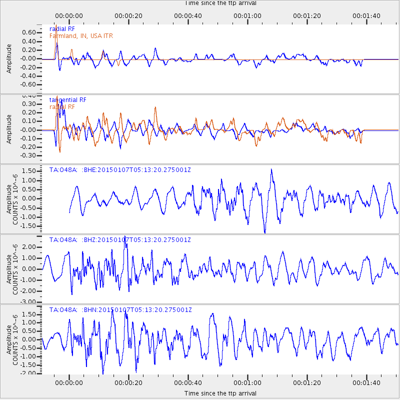
O48A Farmland, IN, USA - Earthquake Result Viewer
*The percent match for this event was below the threshold and hence no stack was calculated.
| Earthquake location: |
South Of Panama |
| Earthquake latitude/longitude: |
5.8/-82.7 |
| Earthquake time(UTC): |
2015/01/07 (007) 05:07:08 GMT |
| Earthquake Depth: |
10 km |
| Earthquake Magnitude: |
6.6 MWP, 6.6 MI |
| Earthquake Catalog/Contributor: |
NEIC PDE/NEIC COMCAT |
|
| Network: |
TA USArray Transportable Network (new EarthScope stations) |
| Station: |
O48A Farmland, IN, USA |
| Lat/Lon: |
40.26 N/85.16 W |
| Elevation: |
300 m |
|
| Distance: |
34.4 deg |
| Az: |
356.604 deg |
| Baz: |
175.584 deg |
| Ray Param: |
$rayparam |
*The percent match for this event was below the threshold and hence was not used in the summary stack. |
|
| Radial Match: |
48.38855 % |
| Radial Bump: |
400 |
| Transverse Match: |
58.1809 % |
| Transverse Bump: |
400 |
| SOD ConfigId: |
3390531 |
| Insert Time: |
2019-04-15 23:20:48.467 +0000 |
| GWidth: |
2.5 |
| Max Bumps: |
400 |
| Tol: |
0.001 |
|
Signal To Noise
| Channel | StoN | STA | LTA |
| TA:O48A: :BHZ:20150107T05:13:20.275001Z | 1.7695816 | 1.0411098E-6 | 5.883368E-7 |
| TA:O48A: :BHN:20150107T05:13:20.275001Z | 1.9999226 | 5.7629103E-7 | 2.8815666E-7 |
| TA:O48A: :BHE:20150107T05:13:20.275001Z | 1.3301868 | 4.1028247E-7 | 3.0843972E-7 |
| Arrivals |
| Ps | |
| PpPs | |
| PsPs/PpSs | |


