You are here: Home > Network List > LD - Lamont-Doherty Cooperative Seismographic Network Stations List
> Station HBVT Hinesburg, VT > Earthquake Result Viewer
HBVT Hinesburg, VT - Earthquake Result Viewer
| Earthquake location: |
Near Coast Of Nicaragua |
| Earthquake latitude/longitude: |
12.6/-87.7 |
| Earthquake time(UTC): |
2014/03/02 (061) 09:37:54 GMT |
| Earthquake Depth: |
60 km |
| Earthquake Magnitude: |
6.2 MWW, 6.2 MWB, 6.2 MWC, 6.3 MWC |
| Earthquake Catalog/Contributor: |
NEIC PDE/NEIC COMCAT |
|
| Network: |
LD Lamont-Doherty Cooperative Seismographic Network |
| Station: |
HBVT Hinesburg, VT |
| Lat/Lon: |
44.36 N/73.07 W |
| Elevation: |
1130 m |
|
| Distance: |
34.1 deg |
| Az: |
18.847 deg |
| Baz: |
206.088 deg |
| Ray Param: |
0.0777616 |
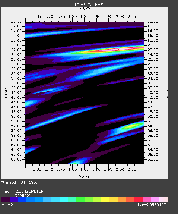
| Estimated Moho Depth: |
21.5 km |
| Estimated Crust Vp/Vs: |
1.99 |
| Assumed Crust Vp: |
6.419 km/s |
| Estimated Crust Vs: |
3.222 km/s |
| Estimated Crust Poisson's Ratio: |
0.33 |
|
| Radial Match: |
84.46957 % |
| Radial Bump: |
377 |
| Transverse Match: |
56.320324 % |
| Transverse Bump: |
360 |
| SOD ConfigId: |
626651 |
| Insert Time: |
2014-04-20 23:19:33.593 +0000 |
| GWidth: |
2.5 |
| Max Bumps: |
400 |
| Tol: |
0.001 |
|

Signal To Noise
| Channel | StoN | STA | LTA |
| LD:HBVT: :HHZ:20140302T09:44:03.335005Z | 6.1164956 | 1.3539174E-6 | 2.2135508E-7 |
| LD:HBVT: :HHN:20140302T09:44:03.335005Z | 2.9143088 | 1.1368351E-6 | 3.900874E-7 |
| LD:HBVT: :HHE:20140302T09:44:03.335005Z | 1.968333 | 5.6993383E-7 | 2.8955154E-7 |
| Arrivals |
| Ps | 3.6 SECOND |
| PpPs | 9.4 SECOND |
| PsPs/PpSs | 13 SECOND |


