You are here: Home > Network List > N4 - Central and EAstern US Network Stations List
> Station D41A Chassel, MI, USA > Earthquake Result Viewer
D41A Chassel, MI, USA - Earthquake Result Viewer
| Earthquake location: |
Near Coast Of Nicaragua |
| Earthquake latitude/longitude: |
12.6/-87.7 |
| Earthquake time(UTC): |
2014/03/02 (061) 09:37:54 GMT |
| Earthquake Depth: |
60 km |
| Earthquake Magnitude: |
6.2 MWW, 6.2 MWB, 6.2 MWC, 6.3 MWC |
| Earthquake Catalog/Contributor: |
NEIC PDE/NEIC COMCAT |
|
| Network: |
N4 Central and EAstern US Network |
| Station: |
D41A Chassel, MI, USA |
| Lat/Lon: |
47.06 N/88.57 W |
| Elevation: |
271 m |
|
| Distance: |
34.4 deg |
| Az: |
358.937 deg |
| Baz: |
178.481 deg |
| Ray Param: |
0.07760006 |
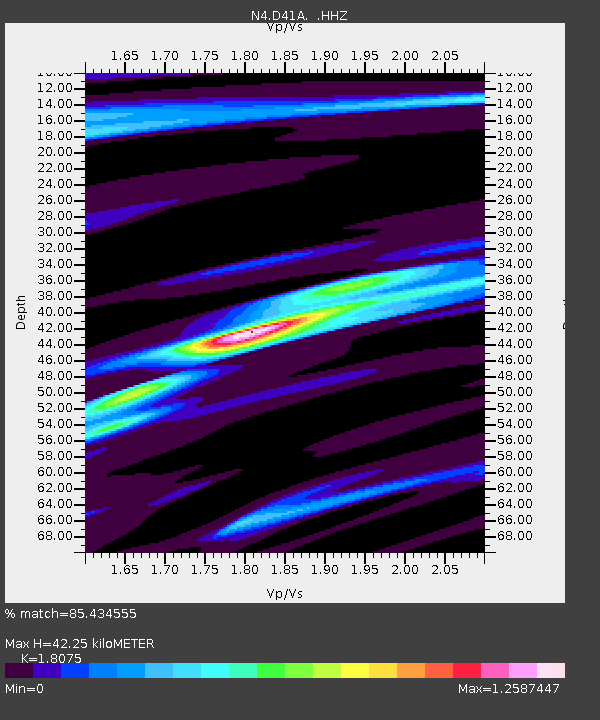
| Estimated Moho Depth: |
42.25 km |
| Estimated Crust Vp/Vs: |
1.81 |
| Assumed Crust Vp: |
6.467 km/s |
| Estimated Crust Vs: |
3.578 km/s |
| Estimated Crust Poisson's Ratio: |
0.28 |
|
| Radial Match: |
85.434555 % |
| Radial Bump: |
225 |
| Transverse Match: |
56.479355 % |
| Transverse Bump: |
345 |
| SOD ConfigId: |
626651 |
| Insert Time: |
2014-04-20 23:20:30.755 +0000 |
| GWidth: |
2.5 |
| Max Bumps: |
400 |
| Tol: |
0.001 |
|

Signal To Noise
| Channel | StoN | STA | LTA |
| N4:D41A: :HHZ:20140302T09:44:06.030012Z | 5.214366 | 1.5027179E-6 | 2.88188E-7 |
| N4:D41A: :HHN:20140302T09:44:06.030012Z | 4.328681 | 9.821914E-7 | 2.2690315E-7 |
| N4:D41A: :HHE:20140302T09:44:06.030012Z | 1.5624869 | 4.0595225E-7 | 2.5981163E-7 |
| Arrivals |
| Ps | 5.7 SECOND |
| PpPs | 17 SECOND |
| PsPs/PpSs | 23 SECOND |


