You are here: Home > Network List > TA - USArray Transportable Network (new EarthScope stations) Stations List
> Station D51A Lot 18 Range III Mazenod Township, QC, CAN > Earthquake Result Viewer
D51A Lot 18 Range III Mazenod Township, QC, CAN - Earthquake Result Viewer
| Earthquake location: |
Near Coast Of Nicaragua |
| Earthquake latitude/longitude: |
12.6/-87.7 |
| Earthquake time(UTC): |
2014/03/02 (061) 09:37:54 GMT |
| Earthquake Depth: |
60 km |
| Earthquake Magnitude: |
6.2 MWW, 6.2 MWB, 6.2 MWC, 6.3 MWC |
| Earthquake Catalog/Contributor: |
NEIC PDE/NEIC COMCAT |
|
| Network: |
TA USArray Transportable Network (new EarthScope stations) |
| Station: |
D51A Lot 18 Range III Mazenod Township, QC, CAN |
| Lat/Lon: |
47.09 N/79.37 W |
| Elevation: |
282 m |
|
| Distance: |
35.1 deg |
| Az: |
9.886 deg |
| Baz: |
194.202 deg |
| Ray Param: |
0.07722473 |
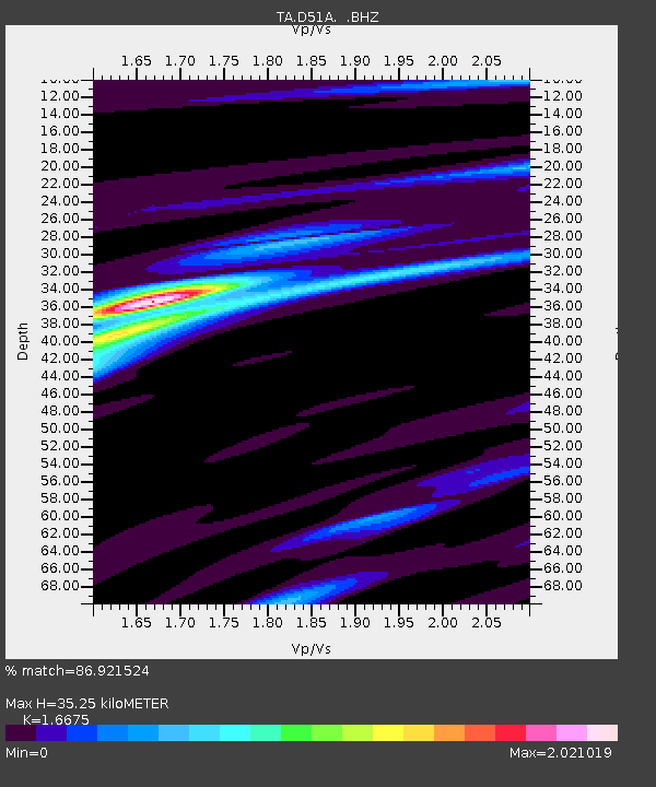
| Estimated Moho Depth: |
35.25 km |
| Estimated Crust Vp/Vs: |
1.67 |
| Assumed Crust Vp: |
6.622 km/s |
| Estimated Crust Vs: |
3.971 km/s |
| Estimated Crust Poisson's Ratio: |
0.22 |
|
| Radial Match: |
86.921524 % |
| Radial Bump: |
278 |
| Transverse Match: |
74.10389 % |
| Transverse Bump: |
360 |
| SOD ConfigId: |
626651 |
| Insert Time: |
2014-04-20 23:25:04.172 +0000 |
| GWidth: |
2.5 |
| Max Bumps: |
400 |
| Tol: |
0.001 |
|
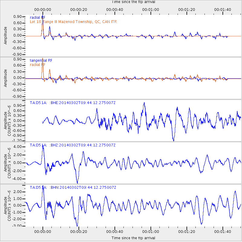
Signal To Noise
| Channel | StoN | STA | LTA |
| TA:D51A: :BHZ:20140302T09:44:12.275007Z | 8.88587 | 2.0036227E-6 | 2.2548413E-7 |
| TA:D51A: :BHN:20140302T09:44:12.275007Z | 2.3576667 | 1.2605171E-6 | 5.3464606E-7 |
| TA:D51A: :BHE:20140302T09:44:12.275007Z | 2.4605386 | 2.9119633E-7 | 1.18346584E-7 |
| Arrivals |
| Ps | 3.9 SECOND |
| PpPs | 13 SECOND |
| PsPs/PpSs | 17 SECOND |


