You are here: Home > Network List > TA - USArray Transportable Network (new EarthScope stations) Stations List
> Station E59A St. Maurice, QC, CAN > Earthquake Result Viewer
E59A St. Maurice, QC, CAN - Earthquake Result Viewer
| Earthquake location: |
Near Coast Of Nicaragua |
| Earthquake latitude/longitude: |
12.6/-87.7 |
| Earthquake time(UTC): |
2014/03/02 (061) 09:37:54 GMT |
| Earthquake Depth: |
60 km |
| Earthquake Magnitude: |
6.2 MWW, 6.2 MWB, 6.2 MWC, 6.3 MWC |
| Earthquake Catalog/Contributor: |
NEIC PDE/NEIC COMCAT |
|
| Network: |
TA USArray Transportable Network (new EarthScope stations) |
| Station: |
E59A St. Maurice, QC, CAN |
| Lat/Lon: |
46.48 N/72.51 W |
| Elevation: |
62 m |
|
| Distance: |
36.2 deg |
| Az: |
17.851 deg |
| Baz: |
205.667 deg |
| Ray Param: |
0.07666368 |
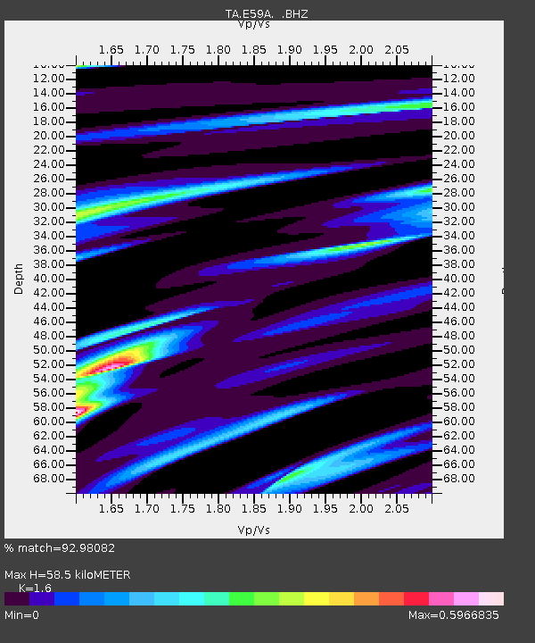
| Estimated Moho Depth: |
58.5 km |
| Estimated Crust Vp/Vs: |
1.60 |
| Assumed Crust Vp: |
6.61 km/s |
| Estimated Crust Vs: |
4.131 km/s |
| Estimated Crust Poisson's Ratio: |
0.18 |
|
| Radial Match: |
92.98082 % |
| Radial Bump: |
262 |
| Transverse Match: |
71.41744 % |
| Transverse Bump: |
400 |
| SOD ConfigId: |
626651 |
| Insert Time: |
2014-04-20 23:26:01.962 +0000 |
| GWidth: |
2.5 |
| Max Bumps: |
400 |
| Tol: |
0.001 |
|
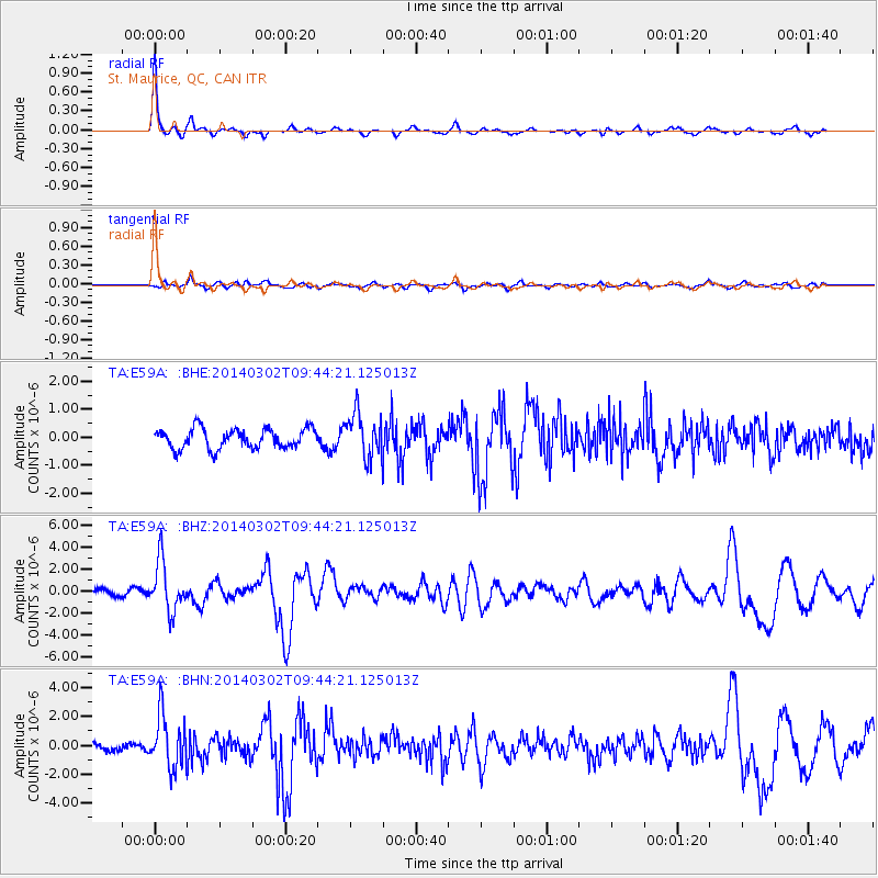
Signal To Noise
| Channel | StoN | STA | LTA |
| TA:E59A: :BHZ:20140302T09:44:21.125013Z | 6.543728 | 2.2502743E-6 | 3.4388262E-7 |
| TA:E59A: :BHN:20140302T09:44:21.125013Z | 7.275305 | 1.8204759E-6 | 2.5022675E-7 |
| TA:E59A: :BHE:20140302T09:44:21.125013Z | 2.2318392 | 7.921728E-7 | 3.549417E-7 |
| Arrivals |
| Ps | 5.8 SECOND |
| PpPs | 21 SECOND |
| PsPs/PpSs | 27 SECOND |


