You are here: Home > Network List > TA - USArray Transportable Network (new EarthScope stations) Stations List
> Station F05D White Salmon, WA, USA > Earthquake Result Viewer
F05D White Salmon, WA, USA - Earthquake Result Viewer

| Earthquake location: |
Near Coast Of Nicaragua |
| Earthquake latitude/longitude: |
12.6/-87.7 |
| Earthquake time(UTC): |
2014/03/02 (061) 09:37:54 GMT |
| Earthquake Depth: |
60 km |
| Earthquake Magnitude: |
6.2 MWW, 6.2 MWB, 6.2 MWC, 6.3 MWC |
| Earthquake Catalog/Contributor: |
NEIC PDE/NEIC COMCAT |
|
| Network: |
TA USArray Transportable Network (new EarthScope stations) |
| Station: |
F05D White Salmon, WA, USA |
| Lat/Lon: |
45.89 N/121.46 W |
| Elevation: |
472 m |
|
| Distance: |
43.8 deg |
| Az: |
325.891 deg |
| Baz: |
128.383 deg |
| Ray Param: |
0.072124496 |
| Estimated Moho Depth: |
60.0 km |
| Estimated Crust Vp/Vs: |
1.93 |
| Assumed Crust Vp: |
6.597 km/s |
| Estimated Crust Vs: |
3.423 km/s |
| Estimated Crust Poisson's Ratio: |
0.32 |
|
| Radial Match: |
84.24433 % |
| Radial Bump: |
340 |
| Transverse Match: |
75.74515 % |
| Transverse Bump: |
350 |
| SOD ConfigId: |
626651 |
| Insert Time: |
2014-04-20 23:26:20.284 +0000 |
| GWidth: |
2.5 |
| Max Bumps: |
400 |
| Tol: |
0.001 |
|
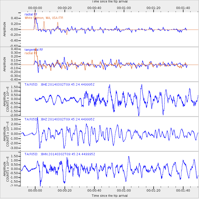
Signal To Noise
| Channel | StoN | STA | LTA |
| TA:F05D: :BHZ:20140302T09:45:24.449995Z | 6.990894 | 1.6230751E-6 | 2.321699E-7 |
| TA:F05D: :BHN:20140302T09:45:24.449995Z | 3.9227068 | 8.0271326E-7 | 2.0463247E-7 |
| TA:F05D: :BHE:20140302T09:45:24.449995Z | 1.8962415 | 5.3865097E-7 | 2.8406242E-7 |
| Arrivals |
| Ps | 9.0 SECOND |
| PpPs | 25 SECOND |
| PsPs/PpSs | 34 SECOND |


