You are here: Home > Network List > TA - USArray Transportable Network (new EarthScope stations) Stations List
> Station F51A Arnstein, ON, CAN > Earthquake Result Viewer
F51A Arnstein, ON, CAN - Earthquake Result Viewer
| Earthquake location: |
Near Coast Of Nicaragua |
| Earthquake latitude/longitude: |
12.6/-87.7 |
| Earthquake time(UTC): |
2014/03/02 (061) 09:37:54 GMT |
| Earthquake Depth: |
60 km |
| Earthquake Magnitude: |
6.2 MWW, 6.2 MWB, 6.2 MWC, 6.3 MWC |
| Earthquake Catalog/Contributor: |
NEIC PDE/NEIC COMCAT |
|
| Network: |
TA USArray Transportable Network (new EarthScope stations) |
| Station: |
F51A Arnstein, ON, CAN |
| Lat/Lon: |
45.93 N/79.92 W |
| Elevation: |
239 m |
|
| Distance: |
33.9 deg |
| Az: |
9.74 deg |
| Baz: |
193.69 deg |
| Ray Param: |
0.07784688 |
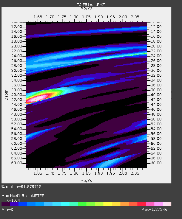
| Estimated Moho Depth: |
41.5 km |
| Estimated Crust Vp/Vs: |
1.64 |
| Assumed Crust Vp: |
6.577 km/s |
| Estimated Crust Vs: |
4.01 km/s |
| Estimated Crust Poisson's Ratio: |
0.20 |
|
| Radial Match: |
91.879715 % |
| Radial Bump: |
177 |
| Transverse Match: |
67.9459 % |
| Transverse Bump: |
388 |
| SOD ConfigId: |
626651 |
| Insert Time: |
2014-04-20 23:26:30.195 +0000 |
| GWidth: |
2.5 |
| Max Bumps: |
400 |
| Tol: |
0.001 |
|
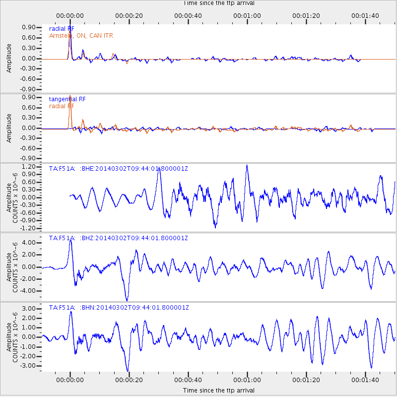
Signal To Noise
| Channel | StoN | STA | LTA |
| TA:F51A: :BHZ:20140302T09:44:01.800001Z | 9.236082 | 2.315481E-6 | 2.5069946E-7 |
| TA:F51A: :BHN:20140302T09:44:01.800001Z | 8.520845 | 1.2598277E-6 | 1.4785245E-7 |
| TA:F51A: :BHE:20140302T09:44:01.800001Z | 3.1129515 | 6.6201426E-7 | 2.1266449E-7 |
| Arrivals |
| Ps | 4.4 SECOND |
| PpPs | 15 SECOND |
| PsPs/PpSs | 20 SECOND |


