You are here: Home > Network List > TA - USArray Transportable Network (new EarthScope stations) Stations List
> Station F61A St Evariste, QC, CAN > Earthquake Result Viewer
F61A St Evariste, QC, CAN - Earthquake Result Viewer
| Earthquake location: |
Near Coast Of Nicaragua |
| Earthquake latitude/longitude: |
12.6/-87.7 |
| Earthquake time(UTC): |
2014/03/02 (061) 09:37:54 GMT |
| Earthquake Depth: |
60 km |
| Earthquake Magnitude: |
6.2 MWW, 6.2 MWB, 6.2 MWC, 6.3 MWC |
| Earthquake Catalog/Contributor: |
NEIC PDE/NEIC COMCAT |
|
| Network: |
TA USArray Transportable Network (new EarthScope stations) |
| Station: |
F61A St Evariste, QC, CAN |
| Lat/Lon: |
45.97 N/70.99 W |
| Elevation: |
350 m |
|
| Distance: |
36.2 deg |
| Az: |
19.832 deg |
| Baz: |
208.358 deg |
| Ray Param: |
0.076648496 |
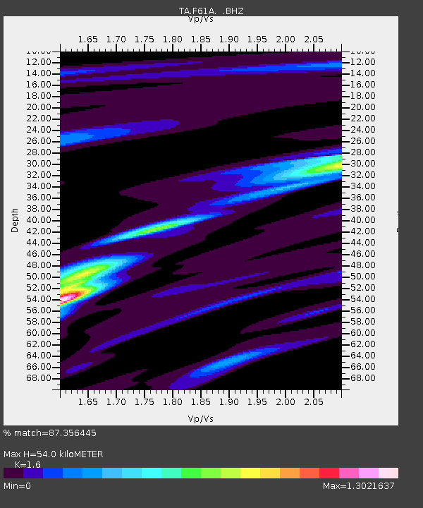
| Estimated Moho Depth: |
54.0 km |
| Estimated Crust Vp/Vs: |
1.60 |
| Assumed Crust Vp: |
6.419 km/s |
| Estimated Crust Vs: |
4.012 km/s |
| Estimated Crust Poisson's Ratio: |
0.18 |
|
| Radial Match: |
87.356445 % |
| Radial Bump: |
224 |
| Transverse Match: |
59.851875 % |
| Transverse Bump: |
400 |
| SOD ConfigId: |
626651 |
| Insert Time: |
2014-04-20 23:26:46.384 +0000 |
| GWidth: |
2.5 |
| Max Bumps: |
400 |
| Tol: |
0.001 |
|
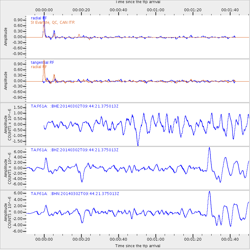
Signal To Noise
| Channel | StoN | STA | LTA |
| TA:F61A: :BHZ:20140302T09:44:21.375013Z | 5.6485305 | 1.7725338E-6 | 3.138044E-7 |
| TA:F61A: :BHN:20140302T09:44:21.375013Z | 4.2106895 | 1.0465035E-6 | 2.4853495E-7 |
| TA:F61A: :BHE:20140302T09:44:21.375013Z | 1.5747734 | 3.3643752E-7 | 2.1364185E-7 |
| Arrivals |
| Ps | 5.5 SECOND |
| PpPs | 20 SECOND |
| PsPs/PpSs | 26 SECOND |


