You are here: Home > Network List > TA - USArray Transportable Network (new EarthScope stations) Stations List
> Station G54A Lake Saint Peter, ON, CAN > Earthquake Result Viewer
G54A Lake Saint Peter, ON, CAN - Earthquake Result Viewer
| Earthquake location: |
Near Coast Of Nicaragua |
| Earthquake latitude/longitude: |
12.6/-87.7 |
| Earthquake time(UTC): |
2014/03/02 (061) 09:37:54 GMT |
| Earthquake Depth: |
60 km |
| Earthquake Magnitude: |
6.2 MWW, 6.2 MWB, 6.2 MWC, 6.3 MWC |
| Earthquake Catalog/Contributor: |
NEIC PDE/NEIC COMCAT |
|
| Network: |
TA USArray Transportable Network (new EarthScope stations) |
| Station: |
G54A Lake Saint Peter, ON, CAN |
| Lat/Lon: |
45.40 N/78.09 W |
| Elevation: |
465 m |
|
| Distance: |
33.7 deg |
| Az: |
12.21 deg |
| Baz: |
197.043 deg |
| Ray Param: |
0.07792605 |
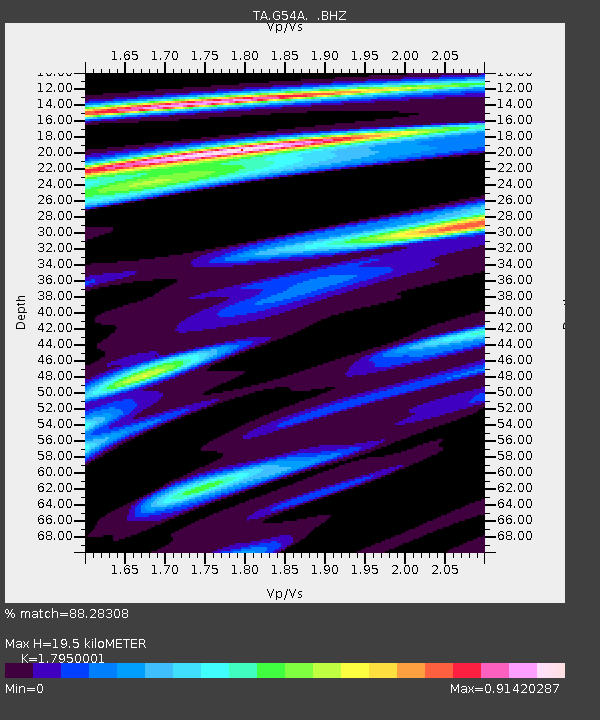
| Estimated Moho Depth: |
19.5 km |
| Estimated Crust Vp/Vs: |
1.80 |
| Assumed Crust Vp: |
6.577 km/s |
| Estimated Crust Vs: |
3.664 km/s |
| Estimated Crust Poisson's Ratio: |
0.27 |
|
| Radial Match: |
88.28308 % |
| Radial Bump: |
246 |
| Transverse Match: |
61.823444 % |
| Transverse Bump: |
378 |
| SOD ConfigId: |
626651 |
| Insert Time: |
2014-04-20 23:27:09.451 +0000 |
| GWidth: |
2.5 |
| Max Bumps: |
400 |
| Tol: |
0.001 |
|

Signal To Noise
| Channel | StoN | STA | LTA |
| TA:G54A: :BHZ:20140302T09:44:00.300001Z | 6.778973 | 2.0634375E-6 | 3.0438792E-7 |
| TA:G54A: :BHN:20140302T09:44:00.300001Z | 7.3950706 | 1.3307816E-6 | 1.7995524E-7 |
| TA:G54A: :BHE:20140302T09:44:00.300001Z | 2.3174188 | 4.8739514E-7 | 2.103181E-7 |
| Arrivals |
| Ps | 2.6 SECOND |
| PpPs | 7.6 SECOND |
| PsPs/PpSs | 10 SECOND |


