You are here: Home > Network List > TA - USArray Transportable Network (new EarthScope stations) Stations List
> Station G60A Masonville, QC, CAN > Earthquake Result Viewer
G60A Masonville, QC, CAN - Earthquake Result Viewer
| Earthquake location: |
Near Coast Of Nicaragua |
| Earthquake latitude/longitude: |
12.6/-87.7 |
| Earthquake time(UTC): |
2014/03/02 (061) 09:37:54 GMT |
| Earthquake Depth: |
60 km |
| Earthquake Magnitude: |
6.2 MWW, 6.2 MWB, 6.2 MWC, 6.3 MWC |
| Earthquake Catalog/Contributor: |
NEIC PDE/NEIC COMCAT |
|
| Network: |
TA USArray Transportable Network (new EarthScope stations) |
| Station: |
G60A Masonville, QC, CAN |
| Lat/Lon: |
45.10 N/72.33 W |
| Elevation: |
391 m |
|
| Distance: |
35.0 deg |
| Az: |
19.093 deg |
| Baz: |
206.803 deg |
| Ray Param: |
0.07730259 |
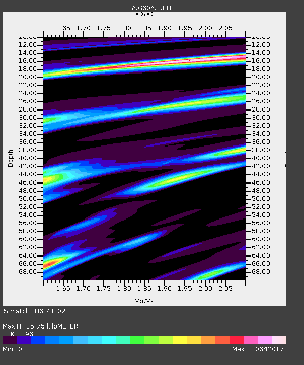
| Estimated Moho Depth: |
15.75 km |
| Estimated Crust Vp/Vs: |
1.96 |
| Assumed Crust Vp: |
6.419 km/s |
| Estimated Crust Vs: |
3.275 km/s |
| Estimated Crust Poisson's Ratio: |
0.32 |
|
| Radial Match: |
86.73102 % |
| Radial Bump: |
264 |
| Transverse Match: |
71.40785 % |
| Transverse Bump: |
400 |
| SOD ConfigId: |
626651 |
| Insert Time: |
2014-04-20 23:27:19.957 +0000 |
| GWidth: |
2.5 |
| Max Bumps: |
400 |
| Tol: |
0.001 |
|
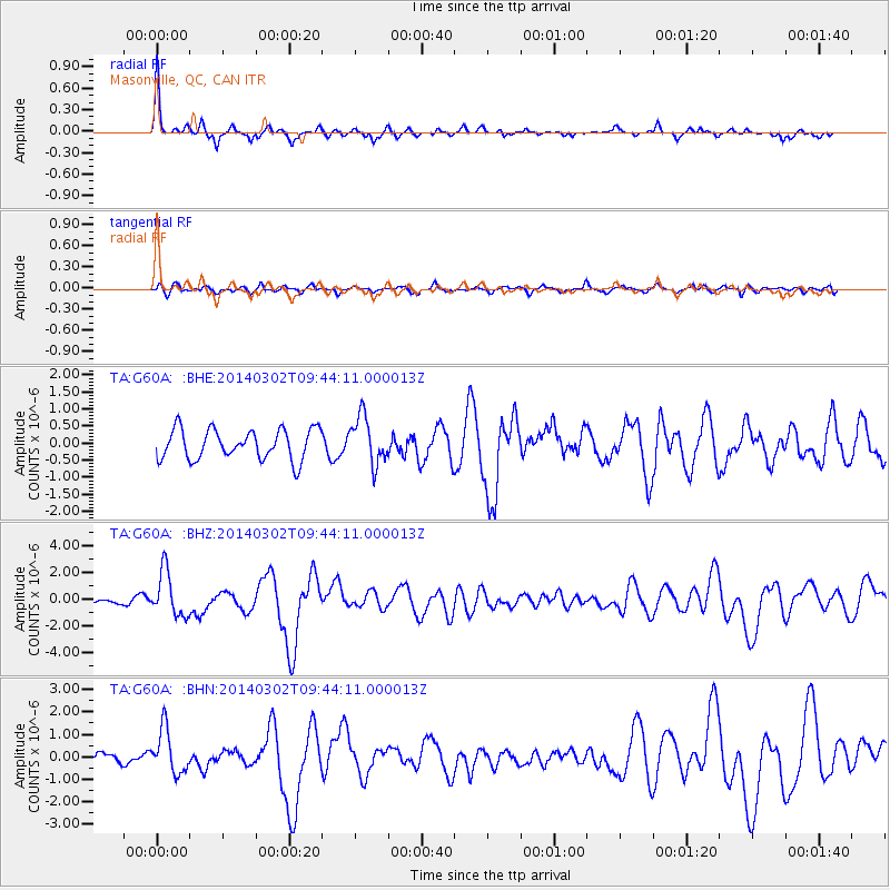
Signal To Noise
| Channel | StoN | STA | LTA |
| TA:G60A: :BHZ:20140302T09:44:11.000013Z | 5.4976816 | 1.6626016E-6 | 3.0241867E-7 |
| TA:G60A: :BHN:20140302T09:44:11.000013Z | 4.7455325 | 9.805731E-7 | 2.0663079E-7 |
| TA:G60A: :BHE:20140302T09:44:11.000013Z | 1.5956525 | 7.012832E-7 | 4.3949623E-7 |
| Arrivals |
| Ps | 2.5 SECOND |
| PpPs | 6.8 SECOND |
| PsPs/PpSs | 9.3 SECOND |


