You are here: Home > Network List > TA - USArray Transportable Network (new EarthScope stations) Stations List
> Station G64A Maxfield, ME, USA > Earthquake Result Viewer
G64A Maxfield, ME, USA - Earthquake Result Viewer
| Earthquake location: |
Near Coast Of Nicaragua |
| Earthquake latitude/longitude: |
12.6/-87.7 |
| Earthquake time(UTC): |
2014/03/02 (061) 09:37:54 GMT |
| Earthquake Depth: |
60 km |
| Earthquake Magnitude: |
6.2 MWW, 6.2 MWB, 6.2 MWC, 6.3 MWC |
| Earthquake Catalog/Contributor: |
NEIC PDE/NEIC COMCAT |
|
| Network: |
TA USArray Transportable Network (new EarthScope stations) |
| Station: |
G64A Maxfield, ME, USA |
| Lat/Lon: |
45.25 N/68.76 W |
| Elevation: |
165 m |
|
| Distance: |
36.4 deg |
| Az: |
22.737 deg |
| Baz: |
212.294 deg |
| Ray Param: |
0.076556325 |
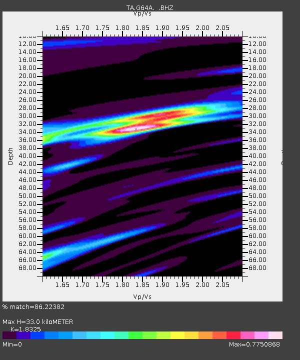
| Estimated Moho Depth: |
33.0 km |
| Estimated Crust Vp/Vs: |
1.83 |
| Assumed Crust Vp: |
6.419 km/s |
| Estimated Crust Vs: |
3.503 km/s |
| Estimated Crust Poisson's Ratio: |
0.29 |
|
| Radial Match: |
86.22382 % |
| Radial Bump: |
221 |
| Transverse Match: |
61.5412 % |
| Transverse Bump: |
385 |
| SOD ConfigId: |
626651 |
| Insert Time: |
2014-04-20 23:27:30.588 +0000 |
| GWidth: |
2.5 |
| Max Bumps: |
400 |
| Tol: |
0.001 |
|

Signal To Noise
| Channel | StoN | STA | LTA |
| TA:G64A: :BHZ:20140302T09:44:22.824995Z | 6.615156 | 2.4110798E-6 | 3.6447813E-7 |
| TA:G64A: :BHN:20140302T09:44:22.824995Z | 5.463736 | 1.4501131E-6 | 2.6540687E-7 |
| TA:G64A: :BHE:20140302T09:44:22.824995Z | 4.119544 | 1.2806099E-6 | 3.1086205E-7 |
| Arrivals |
| Ps | 4.6 SECOND |
| PpPs | 14 SECOND |
| PsPs/PpSs | 18 SECOND |


