You are here: Home > Network List > TA - USArray Transportable Network (new EarthScope stations) Stations List
> Station H60A Morristown, VT, USA > Earthquake Result Viewer
H60A Morristown, VT, USA - Earthquake Result Viewer
| Earthquake location: |
Near Coast Of Nicaragua |
| Earthquake latitude/longitude: |
12.6/-87.7 |
| Earthquake time(UTC): |
2014/03/02 (061) 09:37:54 GMT |
| Earthquake Depth: |
60 km |
| Earthquake Magnitude: |
6.2 MWW, 6.2 MWB, 6.2 MWC, 6.3 MWC |
| Earthquake Catalog/Contributor: |
NEIC PDE/NEIC COMCAT |
|
| Network: |
TA USArray Transportable Network (new EarthScope stations) |
| Station: |
H60A Morristown, VT, USA |
| Lat/Lon: |
44.56 N/72.70 W |
| Elevation: |
459 m |
|
| Distance: |
34.4 deg |
| Az: |
19.109 deg |
| Baz: |
206.56 deg |
| Ray Param: |
0.07761003 |
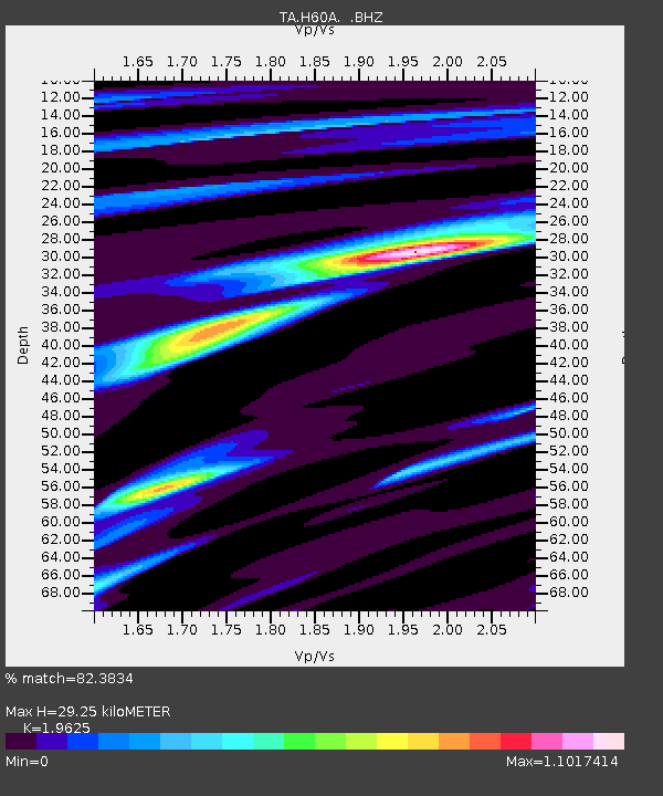
| Estimated Moho Depth: |
29.25 km |
| Estimated Crust Vp/Vs: |
1.96 |
| Assumed Crust Vp: |
6.419 km/s |
| Estimated Crust Vs: |
3.271 km/s |
| Estimated Crust Poisson's Ratio: |
0.32 |
|
| Radial Match: |
82.3834 % |
| Radial Bump: |
243 |
| Transverse Match: |
71.17792 % |
| Transverse Bump: |
400 |
| SOD ConfigId: |
626651 |
| Insert Time: |
2014-04-20 23:28:05.091 +0000 |
| GWidth: |
2.5 |
| Max Bumps: |
400 |
| Tol: |
0.001 |
|

Signal To Noise
| Channel | StoN | STA | LTA |
| TA:H60A: :BHZ:20140302T09:44:05.875013Z | 5.692147 | 1.8831192E-6 | 3.308276E-7 |
| TA:H60A: :BHN:20140302T09:44:05.875013Z | 4.807097 | 1.0242964E-6 | 2.1308004E-7 |
| TA:H60A: :BHE:20140302T09:44:05.875013Z | 3.1444616 | 9.647594E-7 | 3.0681224E-7 |
| Arrivals |
| Ps | 4.7 SECOND |
| PpPs | 13 SECOND |
| PsPs/PpSs | 17 SECOND |


