You are here: Home > Network List > TA - USArray Transportable Network (new EarthScope stations) Stations List
> Station I52A Shelburne, ON, CAN > Earthquake Result Viewer
I52A Shelburne, ON, CAN - Earthquake Result Viewer

| Earthquake location: |
Near Coast Of Nicaragua |
| Earthquake latitude/longitude: |
12.6/-87.7 |
| Earthquake time(UTC): |
2014/03/02 (061) 09:37:54 GMT |
| Earthquake Depth: |
60 km |
| Earthquake Magnitude: |
6.2 MWW, 6.2 MWB, 6.2 MWC, 6.3 MWC |
| Earthquake Catalog/Contributor: |
NEIC PDE/NEIC COMCAT |
|
| Network: |
TA USArray Transportable Network (new EarthScope stations) |
| Station: |
I52A Shelburne, ON, CAN |
| Lat/Lon: |
44.07 N/80.18 W |
| Elevation: |
505 m |
|
| Distance: |
32.1 deg |
| Az: |
10.223 deg |
| Baz: |
193.911 deg |
| Ray Param: |
0.07867837 |
| Estimated Moho Depth: |
42.75 km |
| Estimated Crust Vp/Vs: |
1.72 |
| Assumed Crust Vp: |
6.53 km/s |
| Estimated Crust Vs: |
3.808 km/s |
| Estimated Crust Poisson's Ratio: |
0.24 |
|
| Radial Match: |
93.791176 % |
| Radial Bump: |
314 |
| Transverse Match: |
71.07538 % |
| Transverse Bump: |
400 |
| SOD ConfigId: |
626651 |
| Insert Time: |
2014-04-20 23:28:52.778 +0000 |
| GWidth: |
2.5 |
| Max Bumps: |
400 |
| Tol: |
0.001 |
|
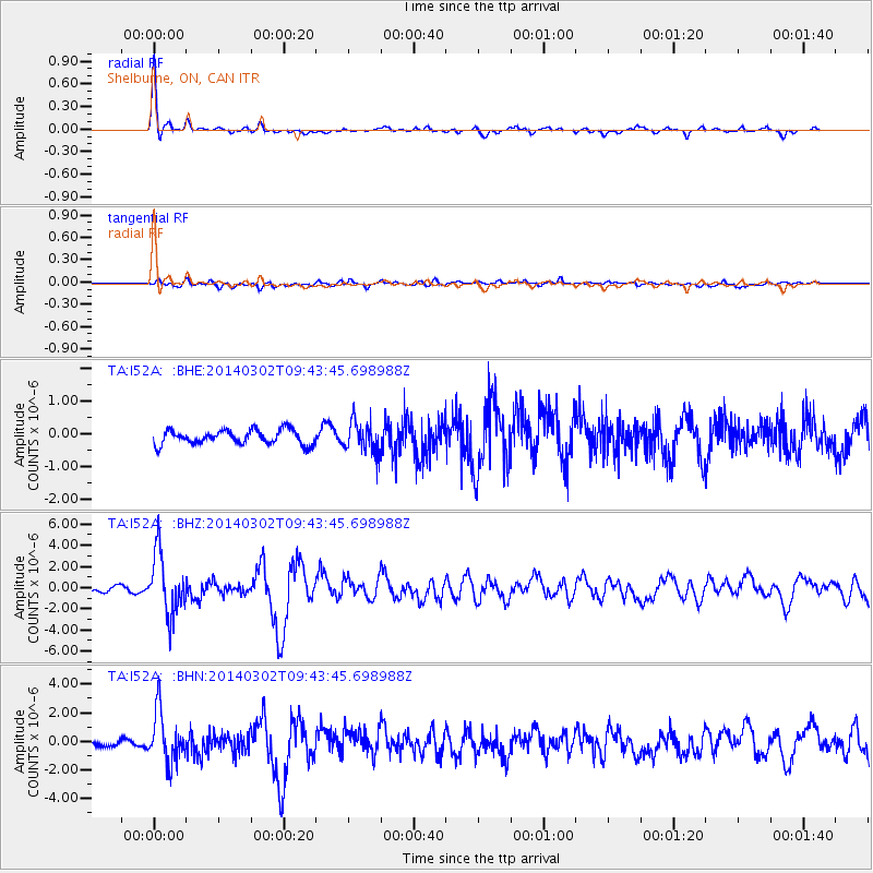
Signal To Noise
| Channel | StoN | STA | LTA |
| TA:I52A: :BHZ:20140302T09:43:45.698988Z | 11.498289 | 2.8948148E-6 | 2.5176047E-7 |
| TA:I52A: :BHN:20140302T09:43:45.698988Z | 9.409182 | 1.7469313E-6 | 1.856624E-7 |
| TA:I52A: :BHE:20140302T09:43:45.698988Z | 2.203571 | 4.799327E-7 | 2.177977E-7 |
| Arrivals |
| Ps | 5.1 SECOND |
| PpPs | 16 SECOND |
| PsPs/PpSs | 21 SECOND |


