You are here: Home > Network List > TA - USArray Transportable Network (new EarthScope stations) Stations List
> Station I57A Carthage, NY, USA > Earthquake Result Viewer
I57A Carthage, NY, USA - Earthquake Result Viewer
| Earthquake location: |
Near Coast Of Nicaragua |
| Earthquake latitude/longitude: |
12.6/-87.7 |
| Earthquake time(UTC): |
2014/03/02 (061) 09:37:54 GMT |
| Earthquake Depth: |
60 km |
| Earthquake Magnitude: |
6.2 MWW, 6.2 MWB, 6.2 MWC, 6.3 MWC |
| Earthquake Catalog/Contributor: |
NEIC PDE/NEIC COMCAT |
|
| Network: |
TA USArray Transportable Network (new EarthScope stations) |
| Station: |
I57A Carthage, NY, USA |
| Lat/Lon: |
43.94 N/75.66 W |
| Elevation: |
321 m |
|
| Distance: |
32.9 deg |
| Az: |
16.071 deg |
| Baz: |
201.971 deg |
| Ray Param: |
0.0782922 |
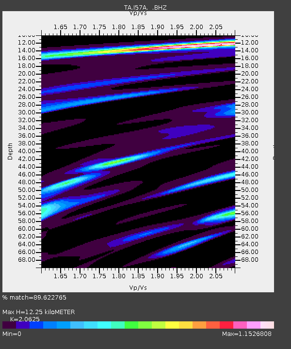
| Estimated Moho Depth: |
12.25 km |
| Estimated Crust Vp/Vs: |
2.06 |
| Assumed Crust Vp: |
6.419 km/s |
| Estimated Crust Vs: |
3.112 km/s |
| Estimated Crust Poisson's Ratio: |
0.35 |
|
| Radial Match: |
89.622765 % |
| Radial Bump: |
302 |
| Transverse Match: |
61.039394 % |
| Transverse Bump: |
367 |
| SOD ConfigId: |
626651 |
| Insert Time: |
2014-04-20 23:28:58.335 +0000 |
| GWidth: |
2.5 |
| Max Bumps: |
400 |
| Tol: |
0.001 |
|

Signal To Noise
| Channel | StoN | STA | LTA |
| TA:I57A: :BHZ:20140302T09:43:53.375013Z | 5.6324067 | 2.0456855E-6 | 3.6319918E-7 |
| TA:I57A: :BHN:20140302T09:43:53.375013Z | 4.2284145 | 1.1220599E-6 | 2.6536185E-7 |
| TA:I57A: :BHE:20140302T09:43:53.375013Z | 3.4186869 | 7.004855E-7 | 2.0489898E-7 |
| Arrivals |
| Ps | 2.2 SECOND |
| PpPs | 5.5 SECOND |
| PsPs/PpSs | 7.6 SECOND |


