You are here: Home > Network List > TA - USArray Transportable Network (new EarthScope stations) Stations List
> Station I58A Old Forge, NY, USA > Earthquake Result Viewer
I58A Old Forge, NY, USA - Earthquake Result Viewer
| Earthquake location: |
Near Coast Of Nicaragua |
| Earthquake latitude/longitude: |
12.6/-87.7 |
| Earthquake time(UTC): |
2014/03/02 (061) 09:37:54 GMT |
| Earthquake Depth: |
60 km |
| Earthquake Magnitude: |
6.2 MWW, 6.2 MWB, 6.2 MWC, 6.3 MWC |
| Earthquake Catalog/Contributor: |
NEIC PDE/NEIC COMCAT |
|
| Network: |
TA USArray Transportable Network (new EarthScope stations) |
| Station: |
I58A Old Forge, NY, USA |
| Lat/Lon: |
43.69 N/74.97 W |
| Elevation: |
599 m |
|
| Distance: |
32.9 deg |
| Az: |
17.09 deg |
| Baz: |
203.301 deg |
| Ray Param: |
0.07830926 |
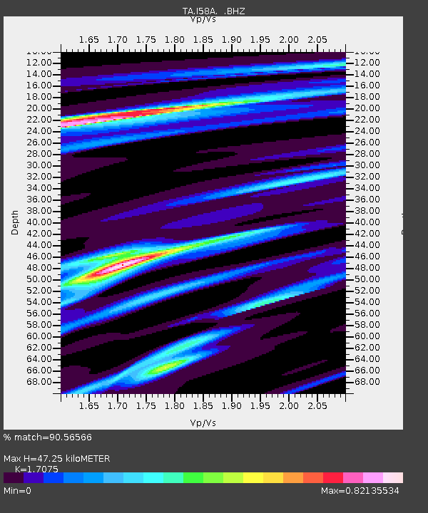
| Estimated Moho Depth: |
47.25 km |
| Estimated Crust Vp/Vs: |
1.71 |
| Assumed Crust Vp: |
6.419 km/s |
| Estimated Crust Vs: |
3.759 km/s |
| Estimated Crust Poisson's Ratio: |
0.24 |
|
| Radial Match: |
90.56566 % |
| Radial Bump: |
192 |
| Transverse Match: |
67.874794 % |
| Transverse Bump: |
400 |
| SOD ConfigId: |
626651 |
| Insert Time: |
2014-04-20 23:29:01.108 +0000 |
| GWidth: |
2.5 |
| Max Bumps: |
400 |
| Tol: |
0.001 |
|
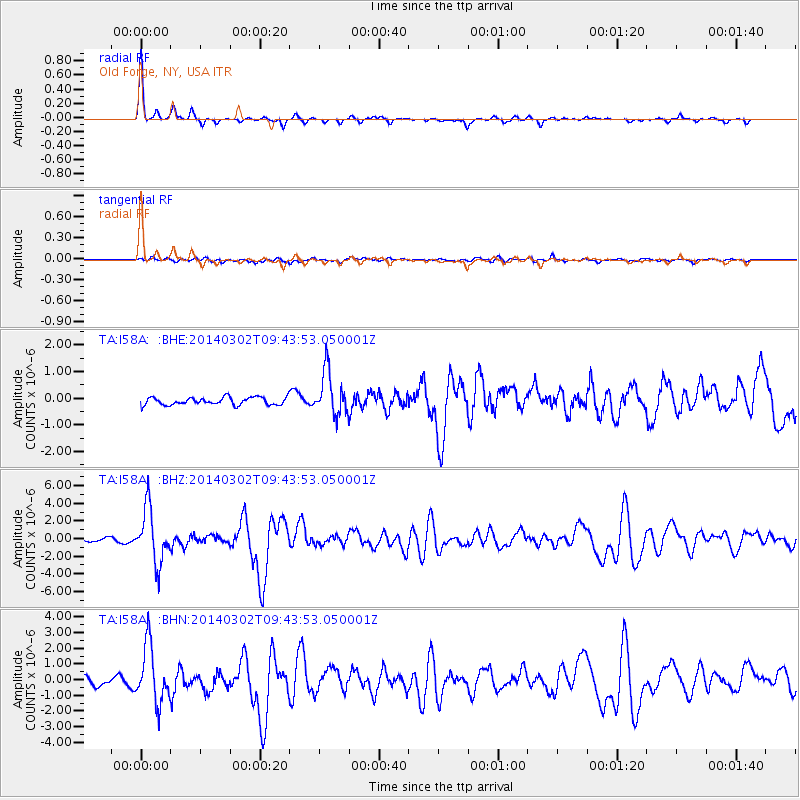
Signal To Noise
| Channel | StoN | STA | LTA |
| TA:I58A: :BHZ:20140302T09:43:53.050001Z | 16.911722 | 3.0708788E-6 | 1.8158286E-7 |
| TA:I58A: :BHN:20140302T09:43:53.050001Z | 5.6440063 | 1.8129645E-6 | 3.2121943E-7 |
| TA:I58A: :BHE:20140302T09:43:53.050001Z | 5.7114763 | 8.115755E-7 | 1.4209557E-7 |
| Arrivals |
| Ps | 5.6 SECOND |
| PpPs | 18 SECOND |
| PsPs/PpSs | 24 SECOND |


