You are here: Home > Network List > TA - USArray Transportable Network (new EarthScope stations) Stations List
> Station I59A Olmsteadville, NY, USA > Earthquake Result Viewer
I59A Olmsteadville, NY, USA - Earthquake Result Viewer
| Earthquake location: |
Near Coast Of Nicaragua |
| Earthquake latitude/longitude: |
12.6/-87.7 |
| Earthquake time(UTC): |
2014/03/02 (061) 09:37:54 GMT |
| Earthquake Depth: |
60 km |
| Earthquake Magnitude: |
6.2 MWW, 6.2 MWB, 6.2 MWC, 6.3 MWC |
| Earthquake Catalog/Contributor: |
NEIC PDE/NEIC COMCAT |
|
| Network: |
TA USArray Transportable Network (new EarthScope stations) |
| Station: |
I59A Olmsteadville, NY, USA |
| Lat/Lon: |
43.80 N/73.87 W |
| Elevation: |
390 m |
|
| Distance: |
33.3 deg |
| Az: |
18.34 deg |
| Baz: |
205.105 deg |
| Ray Param: |
0.07811512 |
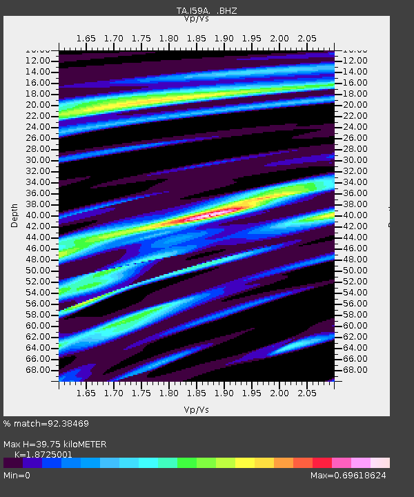
| Estimated Moho Depth: |
39.75 km |
| Estimated Crust Vp/Vs: |
1.87 |
| Assumed Crust Vp: |
6.419 km/s |
| Estimated Crust Vs: |
3.428 km/s |
| Estimated Crust Poisson's Ratio: |
0.30 |
|
| Radial Match: |
92.38469 % |
| Radial Bump: |
236 |
| Transverse Match: |
58.71937 % |
| Transverse Bump: |
360 |
| SOD ConfigId: |
626651 |
| Insert Time: |
2014-04-20 23:29:02.154 +0000 |
| GWidth: |
2.5 |
| Max Bumps: |
400 |
| Tol: |
0.001 |
|
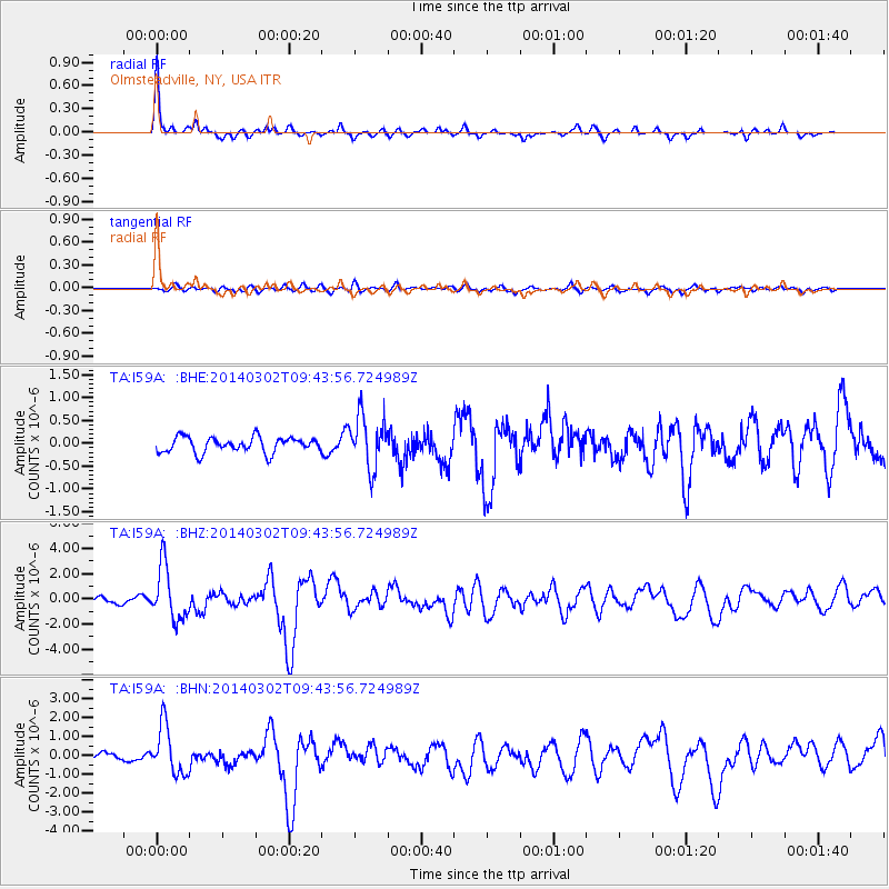
Signal To Noise
| Channel | StoN | STA | LTA |
| TA:I59A: :BHZ:20140302T09:43:56.724989Z | 9.954969 | 2.1253722E-6 | 2.1349861E-7 |
| TA:I59A: :BHN:20140302T09:43:56.724989Z | 4.3591003 | 1.2864883E-6 | 2.9512702E-7 |
| TA:I59A: :BHE:20140302T09:43:56.724989Z | 3.4461873 | 5.708729E-7 | 1.6565346E-7 |
| Arrivals |
| Ps | 5.8 SECOND |
| PpPs | 17 SECOND |
| PsPs/PpSs | 22 SECOND |


