You are here: Home > Network List > TA - USArray Transportable Network (new EarthScope stations) Stations List
> Station I60A Shoreham, VT, USA > Earthquake Result Viewer
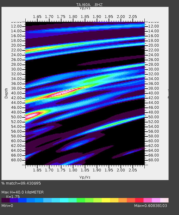
I60A Shoreham, VT, USA - Earthquake Result Viewer
| Earthquake location: |
Near Coast Of Nicaragua |
| Earthquake latitude/longitude: |
12.6/-87.7 |
| Earthquake time(UTC): |
2014/03/02 (061) 09:37:54 GMT |
| Earthquake Depth: |
60 km |
| Earthquake Magnitude: |
6.2 MWW, 6.2 MWB, 6.2 MWC, 6.3 MWC |
| Earthquake Catalog/Contributor: |
NEIC PDE/NEIC COMCAT |
|
| Network: |
TA USArray Transportable Network (new EarthScope stations) |
| Station: |
I60A Shoreham, VT, USA |
| Lat/Lon: |
43.84 N/73.29 W |
| Elevation: |
101 m |
|
| Distance: |
33.6 deg |
| Az: |
18.993 deg |
| Baz: |
206.052 deg |
| Ray Param: |
0.07801149 |
| Estimated Moho Depth: |
40.0 km |
| Estimated Crust Vp/Vs: |
1.75 |
| Assumed Crust Vp: |
6.419 km/s |
| Estimated Crust Vs: |
3.668 km/s |
| Estimated Crust Poisson's Ratio: |
0.26 |
|
| Radial Match: |
89.430695 % |
| Radial Bump: |
208 |
| Transverse Match: |
71.89844 % |
| Transverse Bump: |
299 |
| SOD ConfigId: |
626651 |
| Insert Time: |
2014-04-20 23:29:04.572 +0000 |
| GWidth: |
2.5 |
| Max Bumps: |
400 |
| Tol: |
0.001 |
|

Signal To Noise
| Channel | StoN | STA | LTA |
| TA:I60A: :BHZ:20140302T09:43:58.699995Z | 12.956063 | 2.8545076E-6 | 2.2032214E-7 |
| TA:I60A: :BHN:20140302T09:43:58.699995Z | 12.421432 | 1.7129028E-6 | 1.3789898E-7 |
| TA:I60A: :BHE:20140302T09:43:58.699995Z | 4.258019 | 9.4647464E-7 | 2.222805E-7 |
| Arrivals |
| Ps | 5.1 SECOND |
| PpPs | 16 SECOND |
| PsPs/PpSs | 21 SECOND |


