You are here: Home > Network List > TA - USArray Transportable Network (new EarthScope stations) Stations List
> Station J47A Sunmer, MI, USA > Earthquake Result Viewer
J47A Sunmer, MI, USA - Earthquake Result Viewer
| Earthquake location: |
Near Coast Of Nicaragua |
| Earthquake latitude/longitude: |
12.6/-87.7 |
| Earthquake time(UTC): |
2014/03/02 (061) 09:37:54 GMT |
| Earthquake Depth: |
60 km |
| Earthquake Magnitude: |
6.2 MWW, 6.2 MWB, 6.2 MWC, 6.3 MWC |
| Earthquake Catalog/Contributor: |
NEIC PDE/NEIC COMCAT |
|
| Network: |
TA USArray Transportable Network (new EarthScope stations) |
| Station: |
J47A Sunmer, MI, USA |
| Lat/Lon: |
43.24 N/84.82 W |
| Elevation: |
236 m |
|
| Distance: |
30.7 deg |
| Az: |
4.107 deg |
| Baz: |
185.49 deg |
| Ray Param: |
0.07918661 |
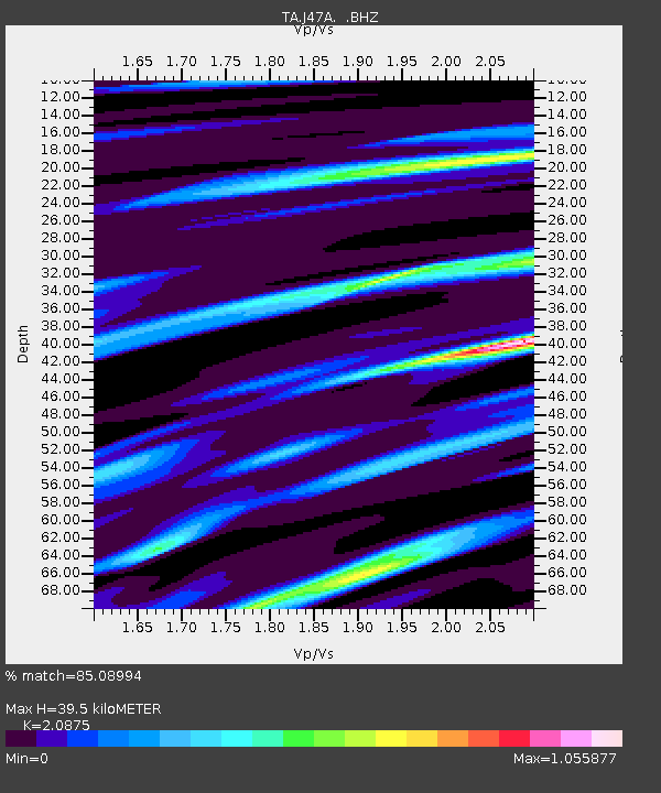
| Estimated Moho Depth: |
39.5 km |
| Estimated Crust Vp/Vs: |
2.09 |
| Assumed Crust Vp: |
6.483 km/s |
| Estimated Crust Vs: |
3.105 km/s |
| Estimated Crust Poisson's Ratio: |
0.35 |
|
| Radial Match: |
85.08994 % |
| Radial Bump: |
351 |
| Transverse Match: |
54.314846 % |
| Transverse Bump: |
400 |
| SOD ConfigId: |
626651 |
| Insert Time: |
2014-04-20 23:29:27.380 +0000 |
| GWidth: |
2.5 |
| Max Bumps: |
400 |
| Tol: |
0.001 |
|
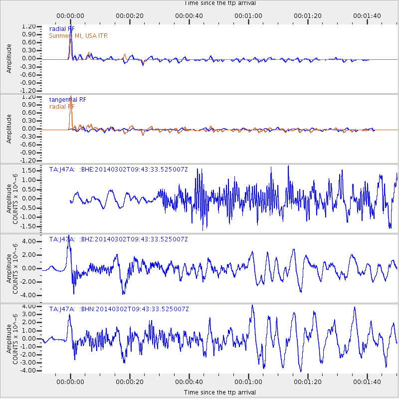
Signal To Noise
| Channel | StoN | STA | LTA |
| TA:J47A: :BHZ:20140302T09:43:33.525007Z | 10.37422 | 2.0805153E-6 | 2.0054668E-7 |
| TA:J47A: :BHN:20140302T09:43:33.525007Z | 4.93273 | 1.3552836E-6 | 2.7475326E-7 |
| TA:J47A: :BHE:20140302T09:43:33.525007Z | 1.3135346 | 3.180209E-7 | 2.421108E-7 |
| Arrivals |
| Ps | 7.1 SECOND |
| PpPs | 18 SECOND |
| PsPs/PpSs | 25 SECOND |


