You are here: Home > Network List > TA - USArray Transportable Network (new EarthScope stations) Stations List
> Station K46A Dorr, MI, USA > Earthquake Result Viewer
K46A Dorr, MI, USA - Earthquake Result Viewer
| Earthquake location: |
Near Coast Of Nicaragua |
| Earthquake latitude/longitude: |
12.6/-87.7 |
| Earthquake time(UTC): |
2014/03/02 (061) 09:37:54 GMT |
| Earthquake Depth: |
60 km |
| Earthquake Magnitude: |
6.2 MWW, 6.2 MWB, 6.2 MWC, 6.3 MWC |
| Earthquake Catalog/Contributor: |
NEIC PDE/NEIC COMCAT |
|
| Network: |
TA USArray Transportable Network (new EarthScope stations) |
| Station: |
K46A Dorr, MI, USA |
| Lat/Lon: |
42.69 N/85.78 W |
| Elevation: |
213 m |
|
| Distance: |
30.1 deg |
| Az: |
2.802 deg |
| Baz: |
183.711 deg |
| Ray Param: |
0.079345666 |
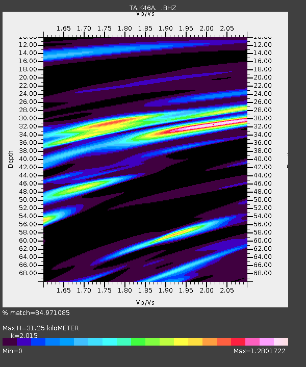
| Estimated Moho Depth: |
31.25 km |
| Estimated Crust Vp/Vs: |
2.02 |
| Assumed Crust Vp: |
6.483 km/s |
| Estimated Crust Vs: |
3.217 km/s |
| Estimated Crust Poisson's Ratio: |
0.34 |
|
| Radial Match: |
84.971085 % |
| Radial Bump: |
400 |
| Transverse Match: |
74.76496 % |
| Transverse Bump: |
400 |
| SOD ConfigId: |
626651 |
| Insert Time: |
2014-04-20 23:30:08.178 +0000 |
| GWidth: |
2.5 |
| Max Bumps: |
400 |
| Tol: |
0.001 |
|

Signal To Noise
| Channel | StoN | STA | LTA |
| TA:K46A: :BHZ:20140302T09:43:28.175001Z | 6.469074 | 1.4399831E-6 | 2.2259493E-7 |
| TA:K46A: :BHN:20140302T09:43:28.175001Z | 6.751215 | 1.2493679E-6 | 1.8505823E-7 |
| TA:K46A: :BHE:20140302T09:43:28.175001Z | 1.3231249 | 3.9288125E-7 | 2.9693436E-7 |
| Arrivals |
| Ps | 5.3 SECOND |
| PpPs | 14 SECOND |
| PsPs/PpSs | 19 SECOND |


