You are here: Home > Network List > TA - USArray Transportable Network (new EarthScope stations) Stations List
> Station K48A Perry, MI, USA > Earthquake Result Viewer
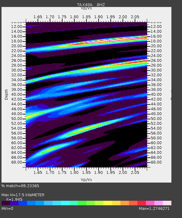
K48A Perry, MI, USA - Earthquake Result Viewer
| Earthquake location: |
Near Coast Of Nicaragua |
| Earthquake latitude/longitude: |
12.6/-87.7 |
| Earthquake time(UTC): |
2014/03/02 (061) 09:37:54 GMT |
| Earthquake Depth: |
60 km |
| Earthquake Magnitude: |
6.2 MWW, 6.2 MWB, 6.2 MWC, 6.3 MWC |
| Earthquake Catalog/Contributor: |
NEIC PDE/NEIC COMCAT |
|
| Network: |
TA USArray Transportable Network (new EarthScope stations) |
| Station: |
K48A Perry, MI, USA |
| Lat/Lon: |
42.80 N/84.12 W |
| Elevation: |
273 m |
|
| Distance: |
30.3 deg |
| Az: |
5.208 deg |
| Baz: |
186.916 deg |
| Ray Param: |
0.079285406 |
| Estimated Moho Depth: |
17.5 km |
| Estimated Crust Vp/Vs: |
1.95 |
| Assumed Crust Vp: |
6.483 km/s |
| Estimated Crust Vs: |
3.333 km/s |
| Estimated Crust Poisson's Ratio: |
0.32 |
|
| Radial Match: |
89.23365 % |
| Radial Bump: |
269 |
| Transverse Match: |
57.607735 % |
| Transverse Bump: |
400 |
| SOD ConfigId: |
626651 |
| Insert Time: |
2014-04-20 23:30:13.519 +0000 |
| GWidth: |
2.5 |
| Max Bumps: |
400 |
| Tol: |
0.001 |
|

Signal To Noise
| Channel | StoN | STA | LTA |
| TA:K48A: :BHZ:20140302T09:43:30.199995Z | 9.148701 | 2.1016042E-6 | 2.2971614E-7 |
| TA:K48A: :BHN:20140302T09:43:30.199995Z | 8.993553 | 1.6311889E-6 | 1.8137312E-7 |
| TA:K48A: :BHE:20140302T09:43:30.199995Z | 1.7715938 | 3.2269298E-7 | 1.821484E-7 |
| Arrivals |
| Ps | 2.7 SECOND |
| PpPs | 7.4 SECOND |
| PsPs/PpSs | 10 SECOND |


